
Archives
Hello Friends
The 60 Days Rapid Revision (RaRe) Series is IASbaba’s Flagship Initiative recommended by Toppers and loved by the aspirants’ community every year.
It is the most comprehensive program which will help you complete the syllabus, revise and practice tests on a daily basis. The Programme on a daily basis includes
Daily Prelims MCQs from Static (Monday – Saturday)
- Daily Static Quiz will cover all the topics of static subjects – Polity, History, Geography, Economics, Environment and Science and technology.
- 20 questions will be posted daily and these questions are framed from the topics mentioned in the schedule.
- It will ensure timely and streamlined revision of your static subjects.
Daily Current Affairs MCQs (Monday – Saturday)
- Daily 5 Current Affairs questions, based on sources like ‘The Hindu’, ‘Indian Express’ and ‘PIB’, would be published from Monday to Saturday according to the schedule.
Daily CSAT Quiz (Monday – Friday)
- CSAT has been an Achilles heel for many aspirants.
- Daily 5 CSAT Questions will be published.
Note – Daily Test of 20 static questions, 10 current affairs, and 5 CSAT questions. (35 Prelims Questions) in QUIZ FORMAT will be updated on a daily basis.
To Know More about 60 Days Rapid Revision (RaRe) Series – CLICK HERE
60 Day Rapid Revision (RaRe) Series Schedule – CLICK HERE
Important Note
- Comment your Scores in the Comment Section. This will keep you accountable, responsible and sincere in days to come.
- It will help us come out with the Cut-Off on a Daily Basis.
- Let us know if you enjoyed today’s test 🙂
- You can post your comments in the given format
- (1) Your Score
- (2) Matrix Meter
- (3) New Learning from the Test
Test-summary
0 of 35 questions completed
Questions:
- 1
- 2
- 3
- 4
- 5
- 6
- 7
- 8
- 9
- 10
- 11
- 12
- 13
- 14
- 15
- 16
- 17
- 18
- 19
- 20
- 21
- 22
- 23
- 24
- 25
- 26
- 27
- 28
- 29
- 30
- 31
- 32
- 33
- 34
- 35
Information
The following Test is based on the syllabus of 60 Days Plan-2023 for UPSC IAS Prelims 2022.
To view Solutions, follow these instructions:
- Click on – ‘Start Test’ button
- Solve Questions
- Click on ‘Test Summary’ button
- Click on ‘Finish Test’ button
- Now click on ‘View Questions’ button – here you will see solutions and links.
You have already completed the test before. Hence you can not start it again.
Test is loading...
You must sign in or sign up to start the test.
You have to finish following test, to start this test:
Results
0 of 35 questions answered correctly
Your time:
Time has elapsed
You have scored 0 points out of 0 points, (0)
| Average score |
|
| Your score |
|
Categories
- Not categorized 0%
| Pos. | Name | Entered on | Points | Result |
|---|---|---|---|---|
| Table is loading | ||||
| No data available | ||||
- 1
- 2
- 3
- 4
- 5
- 6
- 7
- 8
- 9
- 10
- 11
- 12
- 13
- 14
- 15
- 16
- 17
- 18
- 19
- 20
- 21
- 22
- 23
- 24
- 25
- 26
- 27
- 28
- 29
- 30
- 31
- 32
- 33
- 34
- 35
- Answered
- Review
-
Question 1 of 35
1. Question
Consider the following statements
- The Western Ghats is a non-continuous mountain range whereas the Eastern Ghats is a continuous mountain range.
- The height of the Western Ghats is higher than the Eastern Ghats.
- Both the Western Ghats and the Eastern Ghats are spread across 6 states.
- The mountain passes are required to cross the Western Ghats whereas it’s not required in the Eastern Ghats.
How many of the above statements are correct?
Correct
Solution (b)
Statement 1 Statement 2 Statement 3 Statement 4 Incorrect Correct Incorrect Correct The Western Ghats is a continuous mountain range whereas the Eastern Ghats is a non-continuous mountain range. The Western Ghats receive orographic rainfall while the Eastern Ghats do not receive orographic rainfall.
The height of the Western Ghats is higher than the Eastern Ghats. The height of the Western Ghats increases progressively from north to south whereas no such pattern exists in the Eastern Ghats. The Western Ghats are spread over 6 states, namely, Gujarat, Maharashtra, Karnataka, Goa, Kerala, and Tamil Nadu while the Eastern Ghats are spread over 5 states and one union territory, namely, Odisha, Andhra Pradesh, Telangana, Karnataka, and Tamil Nadu. The mountain passes are required to cross the Western Ghats whereas it’s not required in the Eastern Ghats. Incorrect
Solution (b)
Statement 1 Statement 2 Statement 3 Statement 4 Incorrect Correct Incorrect Correct The Western Ghats is a continuous mountain range whereas the Eastern Ghats is a non-continuous mountain range. The Western Ghats receive orographic rainfall while the Eastern Ghats do not receive orographic rainfall.
The height of the Western Ghats is higher than the Eastern Ghats. The height of the Western Ghats increases progressively from north to south whereas no such pattern exists in the Eastern Ghats. The Western Ghats are spread over 6 states, namely, Gujarat, Maharashtra, Karnataka, Goa, Kerala, and Tamil Nadu while the Eastern Ghats are spread over 5 states and one union territory, namely, Odisha, Andhra Pradesh, Telangana, Karnataka, and Tamil Nadu. The mountain passes are required to cross the Western Ghats whereas it’s not required in the Eastern Ghats. -
Question 2 of 35
2. Question
The Tropic of Cancer passes through which of the following states?
- Uttar Pradesh
- Madhya Pradesh
- Jharkhand
- Arunachal Pradesh
- Tripura
- Chhattisgarh
Choose the correct answer code:
Correct
Solution (d)
The Tropic of Cancer passes through the 8 states of India – Gujarat, Rajasthan, Madhya Pradesh, Chhattisgarh, Jharkhand, West Bengal, Tripura and Mizoram.
Incorrect
Solution (d)
The Tropic of Cancer passes through the 8 states of India – Gujarat, Rajasthan, Madhya Pradesh, Chhattisgarh, Jharkhand, West Bengal, Tripura and Mizoram.
-
Question 3 of 35
3. Question
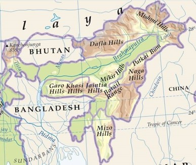
Which the following is correctly arranged Hills from West to East
Correct
Solution (d)
 Incorrect
Solution (d)
-
Question 4 of 35
4. Question
Consider the following statements about Karst Topography
- It is majorly formed by metamorphic rocks.
- It is found in the Himalayas and Vindhya region in India.
- Stalactite and Stalagmite are examples of Karst landforms.
How many of the above statements are correct?
Correct
Solution (b)
Statement 1 Statement 2 Statement 3 Incorrect Correct Correct Karst Topography is majorly formed by sedimentary rocks. It is found in the Himalayas and Vindhya region in India. Stalactite and Stalagmite are examples of Karst landforms. The water containing limestone in solution, seeps through the roof in the form of a continuous chain of drops. A portion of the roof hangs on the roof and on evaporation of water, a small deposit of limestone is left behind contributing to the formation of a stalactite, growing downwards from the roof. The remaining portion of the drop falls to the floor. This also evaporates, leaving behind a small deposit of limestone aiding the formation of a stalagmite, thicker and flatter, rising upwards from the floor.
Other Karst Landforms – Sinking Creeks/Bogas, Arch, Sink Hole and Cavern.
Incorrect
Solution (b)
Statement 1 Statement 2 Statement 3 Incorrect Correct Correct Karst Topography is majorly formed by sedimentary rocks. It is found in the Himalayas and Vindhya region in India. Stalactite and Stalagmite are examples of Karst landforms. The water containing limestone in solution, seeps through the roof in the form of a continuous chain of drops. A portion of the roof hangs on the roof and on evaporation of water, a small deposit of limestone is left behind contributing to the formation of a stalactite, growing downwards from the roof. The remaining portion of the drop falls to the floor. This also evaporates, leaving behind a small deposit of limestone aiding the formation of a stalagmite, thicker and flatter, rising upwards from the floor.
Other Karst Landforms – Sinking Creeks/Bogas, Arch, Sink Hole and Cavern.
-
Question 5 of 35
5. Question
Consider the following statements
- Eons are the largest intervals of geologic time and are divided into smaller time intervals known as eras.
- The extinction of Dinosaurs took place during the Meghalayan age of the Quaternary period.
Choose the correct code:
Correct
Solution (a)
Statement 1 Statement 2 Correct Incorrect Eons are the largest intervals of geologic time and are divided into smaller time intervals known as eras. Geologic Time Scale is made based on Eons, Eras, Periods, and Epochs.
The extinction of Dinosaurs took place during the Cretaceous Period of the Mesozoic era. Jurassic is known as the Age of Dinosaurs. Note:
- The Meghalayan Age is a newly defined stage in the geologic history of the Earth, which spans from 4200 years ago to the present day.
- It is part of the Holocene epoch, and is characterized by a shift from a warm and wet climate to a cooler and drier one, which brought about changes in the monsoon patterns in the region of Meghalaya, India, and led to the development of a new type of soil, the Meghalayan soil.
- The Meghalayan Age is significant as it marks the transition from the mid-Holocene, a time of relative climate stability, to the modern era, which has seen rapid global changes due to human activities.
Incorrect
Solution (a)
Statement 1 Statement 2 Correct Incorrect Eons are the largest intervals of geologic time and are divided into smaller time intervals known as eras. Geologic Time Scale is made based on Eons, Eras, Periods, and Epochs.
The extinction of Dinosaurs took place during the Cretaceous Period of the Mesozoic era. Jurassic is known as the Age of Dinosaurs. Note:
- The Meghalayan Age is a newly defined stage in the geologic history of the Earth, which spans from 4200 years ago to the present day.
- It is part of the Holocene epoch, and is characterized by a shift from a warm and wet climate to a cooler and drier one, which brought about changes in the monsoon patterns in the region of Meghalaya, India, and led to the development of a new type of soil, the Meghalayan soil.
- The Meghalayan Age is significant as it marks the transition from the mid-Holocene, a time of relative climate stability, to the modern era, which has seen rapid global changes due to human activities.
-
Question 6 of 35
6. Question
Consider the following statements
- Batholiths are large granitic intrusive rock bodies which forms the core of huge mountains.
- Laccoliths are large dome-shaped extrusive bodies connected by a pipe-like conduit from below.
- Lapolith is developed into a saucer shape intrusive body.
- Sills are horizontal bodies composed of the intrusive metamorphic rocks.
How many of the above statements are correct?
Correct
Solution (b)
Statement 1 Statement 2 Statement 3 Statement 4 Correct Incorrect Correct Incorrect Batholiths are large granitic intrusive rock bodies which forms the core of huge mountains. Laccoliths are large dome-shaped intrusive bodies connected by a pipe-like conduit from below. Lapolith is developed into a saucer shape intrusive rock body. Sills are horizontal bodies composed of the intrusive igneous rocks. Incorrect
Solution (b)
Statement 1 Statement 2 Statement 3 Statement 4 Correct Incorrect Correct Incorrect Batholiths are large granitic intrusive rock bodies which forms the core of huge mountains. Laccoliths are large dome-shaped intrusive bodies connected by a pipe-like conduit from below. Lapolith is developed into a saucer shape intrusive rock body. Sills are horizontal bodies composed of the intrusive igneous rocks. -
Question 7 of 35
7. Question
Consider the following statements
- The Black Forest Mountain in Germany, Vindhya and Satpura in India are examples of tectonic block mountains.
- The Rockies, the Andes and the Himalayas are examples of tectonic fold mountains.
- The Urals in Russia and the Aravallis in India are examples of residual mountains.
How many of the above statements are correct?
Correct
Solution (c)
Statement 1 Statement 2 Statement 3 Correct Correct Correct The Black Forest Mountain in Germany, Vindhya and Satpura in India are examples of tectonic block mountains. The block mountains are formed because of faulting on a large scale i.e. when large areas or blocks of earth are broken and displaced vertically or horizontally.
The uplifted blocks are termed as horsts, and the lowered blocks are called graben.
The Rockies, the Andes and the Himalayas are examples of tectonic fold mountains. The fold mountains are formed when sedimentary rock strata in geosynclines are subjected to compressive forces.
The Urals in Russia and the Aravallis in India are examples of residual mountains. The residual mountains are the remnants of old fold mountains derived as a result of denudation.
Incorrect
Solution (c)
Statement 1 Statement 2 Statement 3 Correct Correct Correct The Black Forest Mountain in Germany, Vindhya and Satpura in India are examples of tectonic block mountains. The block mountains are formed because of faulting on a large scale i.e. when large areas or blocks of earth are broken and displaced vertically or horizontally.
The uplifted blocks are termed as horsts, and the lowered blocks are called graben.
The Rockies, the Andes and the Himalayas are examples of tectonic fold mountains. The fold mountains are formed when sedimentary rock strata in geosynclines are subjected to compressive forces.
The Urals in Russia and the Aravallis in India are examples of residual mountains. The residual mountains are the remnants of old fold mountains derived as a result of denudation.
-
Question 8 of 35
8. Question
Consider the following statements
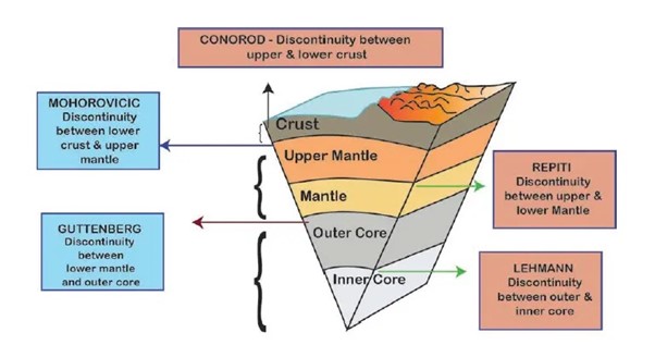
- Mohorovicic Discontinuity is the transition zone between outer mantle and inner mantle.
- Lehman Discontinuity is the transition zone between outer core and inner core.
Which of the statements given above is/are correct?
Correct
Solution (b)
Statement 1 Statement 2 Incorrect Correct Mohorovicic Discontinuity is the transition zone between the crust and mantle Lehman Discontinuity the transition zone between outer core and inner core. Note:
The other discontinuities are –
Conrad Discontinuity is the transition zone between sial and sima.
Repiti Discontinuity is the transition zone between outer mantle and inner mantle.
Gutenberg Discontinuity the transition zone between mantle and core.
 Incorrect
Solution (b)
Statement 1 Statement 2 Incorrect Correct Mohorovicic Discontinuity is the transition zone between the crust and mantle Lehman Discontinuity the transition zone between outer core and inner core. Note:
The other discontinuities are –
Conrad Discontinuity is the transition zone between sial and sima.
Repiti Discontinuity is the transition zone between outer mantle and inner mantle.
Gutenberg Discontinuity the transition zone between mantle and core.
-
Question 9 of 35
9. Question
Consider the following statements
- India shares the longest border with Bangladesh.
- The North to South India’s land stretch is 2,993 km.
- The West to East India’s land stretch is 3,214 km.
- India is the seventh largest country in the world, which occupies around 2.4% of the Earth’s surface.
How many of the above statements are correct?
Correct
Solution (b)
Statement 1 Statement 2 Statement 3 Statement 4 Correct Incorrect Incorrect Correct India shares the longest border with Bangladesh. The North to South India’s land stretch is 3,214 km. The West to East India’s land stretch is 2,993 km. India is the seventh largest country in the world which occupies around 2.4% of the Earth’s surface. Incorrect
Solution (b)
Statement 1 Statement 2 Statement 3 Statement 4 Correct Incorrect Incorrect Correct India shares the longest border with Bangladesh. The North to South India’s land stretch is 3,214 km. The West to East India’s land stretch is 2,993 km. India is the seventh largest country in the world which occupies around 2.4% of the Earth’s surface. -
Question 10 of 35
10. Question
Which state is known as the Molassis basin?
Correct
Solution (a)
Mizoram is known as the Molassis Basin because of the presence of soft unconsolidated deposits. It is also known as the Land of Rolling Mountains because it has huge number of mountains. The formation of most mountains is accompanied by formation valley type depression which runs parallel to mountains. These depressions get accumulated with unconsolidated deposits known as Molassis basin.
Incorrect
Solution (a)
Mizoram is known as the Molassis Basin because of the presence of soft unconsolidated deposits. It is also known as the Land of Rolling Mountains because it has huge number of mountains. The formation of most mountains is accompanied by formation valley type depression which runs parallel to mountains. These depressions get accumulated with unconsolidated deposits known as Molassis basin.
-
Question 11 of 35
11. Question
Consider the following statements about the Composite Volcanoes
- They are also called as Strato-Volcanoes.
- Mauna Kea and Mauna Loa are examples of Composite Volcanoes.
- They are characterised by explosive eruptions.
How many of the above statements are correct?
Correct
Solution (b)
Statement 1 Statement 2 Statement 3 Correct Incorrect Correct The Composite Volcanoes are also called as Strato-Volcanoes because they consist of layers of solid lava flows mixed with layers of sand- or gravel-like volcanic rock called cinders or volcanic ash. Mauna Kea and Mauna Loa are examples of Shield Volcanoes. The Shield Volcanoes are not very steep but are far and wider. They extend to great height as well as distance. They are the largest of all volcanoes in the world as the lava flows to a far distance. They are mostly made up of basalt and are not very explosive.
They are characterised by explosive eruptions as they erupt more viscous lavas than basalt. Incorrect
Solution (b)
Statement 1 Statement 2 Statement 3 Correct Incorrect Correct The Composite Volcanoes are also called as Strato-Volcanoes because they consist of layers of solid lava flows mixed with layers of sand- or gravel-like volcanic rock called cinders or volcanic ash. Mauna Kea and Mauna Loa are examples of Shield Volcanoes. The Shield Volcanoes are not very steep but are far and wider. They extend to great height as well as distance. They are the largest of all volcanoes in the world as the lava flows to a far distance. They are mostly made up of basalt and are not very explosive.
They are characterised by explosive eruptions as they erupt more viscous lavas than basalt. -
Question 12 of 35
12. Question
The Nilgiris along the west coast are relatively tectonically stable as compared to the Himalayas but, still, debris avalanches and landslides occur though not as frequently as in the Himalayas, in these hills. Why?
- Many slopes in Nilgiris are steeper with almost vertical cliffs and escarpments.
- Mechanical weathering due to temperature changes and ranges is pronounced in this region.
- They are mostly made up of sedimentary rocks and unconsolidated and semi-consolidated deposits.
- They receive heavy amounts of rainfall over short periods.
How many of the above statements are correct?
Correct
Solution (c)
Statement 1 Statement 2 Statement 3 Statement 4 Correct Correct Incorrect Correct Many slopes are steeper with almost vertical cliffs and escarpments in the Western Ghats and Nilgiris. They have almost a vertical elongation where ‘snowballing’ of debris avalanches and landslide can easily happen. Mechanical weathering due to temperature changes and ranges is pronounced due to the western ghats proximity towards the equator where it receives high temperature and high Rainfall. This causes solifluction which may sometimes result in landslides as well.
In India, debris avalanches and landslides occur very frequently in the Himalayas because the Himalayas are tectonically active. They are mostly made up of sedimentary rocks and unconsolidated and semi-consolidated deposits. The slopes are very steep. The Nilgiris are mainly composed of metamorphic rocks like gneiss and crystalline schist.
They receive a heavy amount of rainfall over a short period. Most of the rainfall received in the area is mostly in the Monsoon season itself. Incorrect
Solution (c)
Statement 1 Statement 2 Statement 3 Statement 4 Correct Correct Incorrect Correct Many slopes are steeper with almost vertical cliffs and escarpments in the Western Ghats and Nilgiris. They have almost a vertical elongation where ‘snowballing’ of debris avalanches and landslide can easily happen. Mechanical weathering due to temperature changes and ranges is pronounced due to the western ghats proximity towards the equator where it receives high temperature and high Rainfall. This causes solifluction which may sometimes result in landslides as well.
In India, debris avalanches and landslides occur very frequently in the Himalayas because the Himalayas are tectonically active. They are mostly made up of sedimentary rocks and unconsolidated and semi-consolidated deposits. The slopes are very steep. The Nilgiris are mainly composed of metamorphic rocks like gneiss and crystalline schist.
They receive a heavy amount of rainfall over a short period. Most of the rainfall received in the area is mostly in the Monsoon season itself. -
Question 13 of 35
13. Question
Consider the following statements concerning types of Plains:
- Structural plains are formed by horizontally bedded rocks, relatively undisturbed by crustal movements of the earth.
- Depositional plains are comparatively level but rise gently towards adjacent highlands.
- Erosional plains are carved by the agents of erosion, rain, rivers, ice and wind.
How many of the above statements are correct?
Correct
Solution (c)
Statement 1 Statement 2 Statement 3 Correct Correct Correct Structural plain These are structurally depressed areas of the world that make up some of the most extensive natural lowlands on the earth.
They are formed by horizontally bedded rocks, relatively undisturbed by crustal movements of the earth.
Depositional plains These are formed by the deposition of materials brought by various agents of transportation. They are comparatively level but rise gently towards adjacent highlands. Their fertility and economic development depend greatly on the types of sediments that they’re laid down.
Erosional plains These plains are carved by the agents of erosion, rain, river, ice and wind help to smooth out the irregularities of the earth’s surface, and in terms of millions of years, even high mountains can be reduced to low undulating plains.
Incorrect
Solution (c)
Statement 1 Statement 2 Statement 3 Correct Correct Correct Structural plain These are structurally depressed areas of the world that make up some of the most extensive natural lowlands on the earth.
They are formed by horizontally bedded rocks, relatively undisturbed by crustal movements of the earth.
Depositional plains These are formed by the deposition of materials brought by various agents of transportation. They are comparatively level but rise gently towards adjacent highlands. Their fertility and economic development depend greatly on the types of sediments that they’re laid down.
Erosional plains These plains are carved by the agents of erosion, rain, river, ice and wind help to smooth out the irregularities of the earth’s surface, and in terms of millions of years, even high mountains can be reduced to low undulating plains.
-
Question 14 of 35
14. Question
Which of the following characteristic feature of fluvial Erosional landforms is/are correctly matched?
- Gorges: They are formed due to active downcutting of the valleys through the mechanism of pothole drilling during the youth stage.
- Potholes: They are generally formed in coarse-grained rocks such as sandstones and granites.
- Waterfalls: They are formed due to variations in the relative resistance of rocks.
How many of the above pairs are correctly matched?
Correct
Solution (c)
Statement 1 Statement 2 Statement 3 Correct Correct Correct Gorges are formed due to active downcutting of the valleys through the mechanism of pothole drilling during the youth stage of the fluvial cycle of erosion. Gorges are also formed due to the recession of waterfalls. Most of the Himalayan Rivers have carved out deep and narrow gorges.
The kettle-like small depressions in the rocky beds of the river valleys are called potholes which are usually cylindrical in shape. Potholes are generally formed in coarse-grained rocks such as sandstones and granites. Waterfalls form as streams flow from soft rock to hard rock. This happens both laterally (as a stream flows across the earth) and vertically (as the stream drops in a waterfall). In both cases, the soft rock erodes, leaving a hard ledge over which the stream falls. This happens due to variations in the relative resistance of rocks. Incorrect
Solution (c)
Statement 1 Statement 2 Statement 3 Correct Correct Correct Gorges are formed due to active downcutting of the valleys through the mechanism of pothole drilling during the youth stage of the fluvial cycle of erosion. Gorges are also formed due to the recession of waterfalls. Most of the Himalayan Rivers have carved out deep and narrow gorges.
The kettle-like small depressions in the rocky beds of the river valleys are called potholes which are usually cylindrical in shape. Potholes are generally formed in coarse-grained rocks such as sandstones and granites. Waterfalls form as streams flow from soft rock to hard rock. This happens both laterally (as a stream flows across the earth) and vertically (as the stream drops in a waterfall). In both cases, the soft rock erodes, leaving a hard ledge over which the stream falls. This happens due to variations in the relative resistance of rocks. -
Question 15 of 35
15. Question
Consider the following statements about glaciers
- Erosion by glaciers is huge because of friction caused by sheer weight of the ice sheet.
- The cirques are found at the heads of glacial valleys, mostly having tarn lakes.
- Moraines are long ridges of deposits of glacial till
How many of the above statements are correct?
Correct
Solution (c)
Statement 1 Statement 2 Statement 3 Correct Correct Correct Masses of ice moving as sheets over the land or as linear flows down the slopes of mountains in a broad trough like valleys are called glaciers. The movement of glaciers is slow unlike water flow. The erosion by glaciers is tremendous because of friction caused by sheer weight of ice. Cirque is the most common of landforms in glaciated mountains. The cirques are often found at the head of glacial valleys. A lake of water is usually formed within the cirque. This lake is known as Tarn Lake. Moraines are long ridges of deposits of glacial till. When these deposits are at the end of a glacier, they are called Terminal moraines and when they are deposited on both sides, they are called Lateral moraines. When lateral moraines of two glaciers join together, they form Medial moraines. When the lateral moraines of both sides of a glacier join together, it forms a horseshoe shape. Ground moraines are deposits left behind in areas once covered by a glacier Incorrect
Solution (c)
Statement 1 Statement 2 Statement 3 Correct Correct Correct Masses of ice moving as sheets over the land or as linear flows down the slopes of mountains in a broad trough like valleys are called glaciers. The movement of glaciers is slow unlike water flow. The erosion by glaciers is tremendous because of friction caused by sheer weight of ice. Cirque is the most common of landforms in glaciated mountains. The cirques are often found at the head of glacial valleys. A lake of water is usually formed within the cirque. This lake is known as Tarn Lake. Moraines are long ridges of deposits of glacial till. When these deposits are at the end of a glacier, they are called Terminal moraines and when they are deposited on both sides, they are called Lateral moraines. When lateral moraines of two glaciers join together, they form Medial moraines. When the lateral moraines of both sides of a glacier join together, it forms a horseshoe shape. Ground moraines are deposits left behind in areas once covered by a glacier -
Question 16 of 35
16. Question
Which of the following statements defines the significance of the process of weathering?
- Weathering provides regolith for the formation of soil.
- Weathering produces concentrations of valuable mineral ores of iron, manganese, tin, etc.
- Weathering aids mass wasting and reduction of relief.
How many of the above statements are correct?
Correct
Solution (c)
Statement 1 Statement 2 Statement 3 Correct Correct Correct It converts bedrock into regolith and soil. Regolith is also notable for being the basic source of the inorganic part of the soil. The importance of soil which indirectly supports all animal forms of life in the form of vegetation cannot be overemphasized. Weathering creates raw material that becomes sediments and sedimentary rocks- loosens to individual minerals, attack and alter individual minerals and solution.
It forms economic deposits/ importance in engineering projects.
Weathering breaks rocks into their mineral components. It also creates new compounds through chemical changes.
During the prolonged period, the weathering processes produce concentrations of valuable mineral ores of iron, manganese, tin, aluminium, uranium etc. For example, by chemical weathering soluble bases and even silica are removed, leaving behind increasingly rich residual concentrations of metallic oxides. This occurs under humid tropical climatic conditions as part of the lateralization process.
Weathering processes are responsible for breaking down the rocks into smaller fragments and preparing the way for the formation of not only regolith and soils but also erosion and mass movements. Incorrect
Solution (c)
Statement 1 Statement 2 Statement 3 Correct Correct Correct It converts bedrock into regolith and soil. Regolith is also notable for being the basic source of the inorganic part of the soil. The importance of soil which indirectly supports all animal forms of life in the form of vegetation cannot be overemphasized. Weathering creates raw material that becomes sediments and sedimentary rocks- loosens to individual minerals, attack and alter individual minerals and solution.
It forms economic deposits/ importance in engineering projects.
Weathering breaks rocks into their mineral components. It also creates new compounds through chemical changes.
During the prolonged period, the weathering processes produce concentrations of valuable mineral ores of iron, manganese, tin, aluminium, uranium etc. For example, by chemical weathering soluble bases and even silica are removed, leaving behind increasingly rich residual concentrations of metallic oxides. This occurs under humid tropical climatic conditions as part of the lateralization process.
Weathering processes are responsible for breaking down the rocks into smaller fragments and preparing the way for the formation of not only regolith and soils but also erosion and mass movements. -
Question 17 of 35
17. Question
Which of the following factors act as the requisite for the mass movement?
- Decrease in gradient and height of slopes.
- Removal of material from over the original slope surfaces.
- Saturation and lubrication of slope materials.
How many of the above statements are correct?
Correct
Solution (b)
Mass Movement is the movement of masses of bodies of mud, bedrock, soil, and rock debris, which commonly happen along steep-sided hills and mountains because of the gravitational pull.
Gravity exerts its force on all matter, both bedrock and the products of weathering.
Statement 1 Statement 2 Statement 3 Incorrect Correct Correct In order for Mass Movements to happen, there has to be an increase in the gradient and height of slopes. This causes more debris to be attracted downwards. If there is a removal of material or load from over the original slope surfaces. The debris from higher in the relief gets attracted downwards due to gravitational attraction thereby triggering Mass movement. Saturation and lubrication of slope materials happen because of overloading due to heavy rainfall, This creates loosely packed mud and debris movement down the slope of the hills. Incorrect
Solution (b)
Mass Movement is the movement of masses of bodies of mud, bedrock, soil, and rock debris, which commonly happen along steep-sided hills and mountains because of the gravitational pull.
Gravity exerts its force on all matter, both bedrock and the products of weathering.
Statement 1 Statement 2 Statement 3 Incorrect Correct Correct In order for Mass Movements to happen, there has to be an increase in the gradient and height of slopes. This causes more debris to be attracted downwards. If there is a removal of material or load from over the original slope surfaces. The debris from higher in the relief gets attracted downwards due to gravitational attraction thereby triggering Mass movement. Saturation and lubrication of slope materials happen because of overloading due to heavy rainfall, This creates loosely packed mud and debris movement down the slope of the hills. -
Question 18 of 35
18. Question
Match the following
Erosional Landform Agents
- Serrated ridges – Groundwater
- Deflation Hollows – Glacier
- Sink Holes – Wind
How many of the above pairs are correctly matched?
Correct
Solution (d)
Statement 1 Statement 2 Statement 3 Incorrect Incorrect Incorrect Serrated Ridges: Horns form through headward erosion of the cirque walls. If three or more radiating glaciers cut headward until their cirques meet, high, sharp-pointed and steep-sided peaks called horns form. The divides between cirque side walls or head walls get narrow because of progressive erosion and turn into serrated or saw-toothed ridges sometimes referred to as arêtes with very sharp crests and a zig-zag outline.
Deflation Hollows: Weathered mantle from over the rocks or bare soil, gets blown out by the persistent movement of wind currents in one direction. This process may create shallow depressions called Deflation hollows Sinkholes: Small to medium-sized rounded to sub-rounded shallow depressions called swallow holes forms on the surface of rocks like limestone by the action of the solution. A sinkhole is an opening more or less circular at the top and funnel-shaped towards the bottom. Incorrect
Solution (d)
Statement 1 Statement 2 Statement 3 Incorrect Incorrect Incorrect Serrated Ridges: Horns form through headward erosion of the cirque walls. If three or more radiating glaciers cut headward until their cirques meet, high, sharp-pointed and steep-sided peaks called horns form. The divides between cirque side walls or head walls get narrow because of progressive erosion and turn into serrated or saw-toothed ridges sometimes referred to as arêtes with very sharp crests and a zig-zag outline.
Deflation Hollows: Weathered mantle from over the rocks or bare soil, gets blown out by the persistent movement of wind currents in one direction. This process may create shallow depressions called Deflation hollows Sinkholes: Small to medium-sized rounded to sub-rounded shallow depressions called swallow holes forms on the surface of rocks like limestone by the action of the solution. A sinkhole is an opening more or less circular at the top and funnel-shaped towards the bottom. -
Question 19 of 35
19. Question
Arrange the following coastal landforms in the increasing order of erosion level they are subjected to
- Stacks
- Sea caves
- Sea arches
Select the correct answer using the codes given below
Correct
Solution (b)
The erosion and deposition of the sea waves give rise to coastal landforms.
Sea waves continuously strike at the rocks which leads to the development of cracks. Over time they become larger and wider. Thus, hollow caves are formed on the rocks. They are called sea caves. As these cavities become bigger and bigger only the roof of the caves remain, thus forming sea arches. Further, erosion breaks the roof and only walls are left. These wall-like features are called stacks
Incorrect
Solution (b)
The erosion and deposition of the sea waves give rise to coastal landforms.
Sea waves continuously strike at the rocks which leads to the development of cracks. Over time they become larger and wider. Thus, hollow caves are formed on the rocks. They are called sea caves. As these cavities become bigger and bigger only the roof of the caves remain, thus forming sea arches. Further, erosion breaks the roof and only walls are left. These wall-like features are called stacks
-
Question 20 of 35
20. Question
The phenomenon of wearing down of relief variations of the surface of the earth through erosion is known as:
Correct
Solution (a)
Statement 1 Statement 2 Statement 3 Statement 4 Correct Incorrect Incorrect Incorrect The phenomenon of wearing down of relief variations of the surface of the earth through erosion is known as gradation. A deposition is a geological process in which sediments, soil and rocks are added to a landform or landmass Diastrophism is the process of deformation of the Earth’s crust which involves folding and faulting Volcanism, vulcanism or volcanicity is the phenomenon of eruption of molten rock (magma) onto the surface of the Earth or a solid-surface planet or moon, where lava, pyroclastics, and volcanic gases erupt through a break in the surface called a vent. Incorrect
Solution (a)
Statement 1 Statement 2 Statement 3 Statement 4 Correct Incorrect Incorrect Incorrect The phenomenon of wearing down of relief variations of the surface of the earth through erosion is known as gradation. A deposition is a geological process in which sediments, soil and rocks are added to a landform or landmass Diastrophism is the process of deformation of the Earth’s crust which involves folding and faulting Volcanism, vulcanism or volcanicity is the phenomenon of eruption of molten rock (magma) onto the surface of the Earth or a solid-surface planet or moon, where lava, pyroclastics, and volcanic gases erupt through a break in the surface called a vent. -
Question 21 of 35
21. Question
Consider the following statements:
- Tylototriton zaimeng is a newly discovered snake species.
- Zaimeng is a mountain lake located atop the Khongtheng mountain range in Mizoram.
Choose the correct code:
Correct
Solution (d)
- Tylototriton zaimeng is a newly discovered salamander species. Hence statement 1 is incorrect.
- Its habitat is confined to the Khongtheng mountain range in Manipur.
- Salamanders are a group of amphibians typically characterized by their lizard-like appearance, with slender bodies, blunt snouts, short limbs projecting at right angles to the body, and the presence of a tail in both larvae and adults.
- Zaimeng is a mountain lake located atop the Khongtheng mountain range in Manipur. Hence statement 2 is incorrect.
- Zaimeng is the dialect spoken by the Liangmai people, a Naga tribe residing both in Nagaland and Manipur.
- Zaimeng in the Liangmai Naga dialect means “puzzle” or “mystery”.
Incorrect
Solution (d)
- Tylototriton zaimeng is a newly discovered salamander species. Hence statement 1 is incorrect.
- Its habitat is confined to the Khongtheng mountain range in Manipur.
- Salamanders are a group of amphibians typically characterized by their lizard-like appearance, with slender bodies, blunt snouts, short limbs projecting at right angles to the body, and the presence of a tail in both larvae and adults.
- Zaimeng is a mountain lake located atop the Khongtheng mountain range in Manipur. Hence statement 2 is incorrect.
- Zaimeng is the dialect spoken by the Liangmai people, a Naga tribe residing both in Nagaland and Manipur.
- Zaimeng in the Liangmai Naga dialect means “puzzle” or “mystery”.
-
Question 22 of 35
22. Question
Consider the following statements about the Smart Access to Marine Users for Ocean Data Resources and Advisories (SAMUDRA) App:
- It provides comprehensive information on all ocean-related services, useful for both seafarers and the fishing community.
- It is launched by the Ministry of Shipping and empowers users with real-time updates and critical alerts on oceanic disasters.
Choose the correct code:
Correct
Solution (a)
- The Smart Access to Marine Users for Ocean Data Resources and Advisories (SAMUDRA) app provides comprehensive information on all ocean-related services, useful for both seafarers and the fishing community. Hence statement 1 is correct.
- It is launched by the Indian National Centre for Ocean Information Services(INCOIS)
under the Ministry of Earth Sciences (MoES) and empowers users with real-time updates and critical alerts on oceanic disasters such as tsunamis, storm surges, high waves, and swell surge alerts, for the individuals and communities to stay informed and take necessary precautions towards the protection of lives and property. Hence statement 2 is incorrect.
Incorrect
Solution (a)
- The Smart Access to Marine Users for Ocean Data Resources and Advisories (SAMUDRA) app provides comprehensive information on all ocean-related services, useful for both seafarers and the fishing community. Hence statement 1 is correct.
- It is launched by the Indian National Centre for Ocean Information Services(INCOIS)
under the Ministry of Earth Sciences (MoES) and empowers users with real-time updates and critical alerts on oceanic disasters such as tsunamis, storm surges, high waves, and swell surge alerts, for the individuals and communities to stay informed and take necessary precautions towards the protection of lives and property. Hence statement 2 is incorrect.
-
Question 23 of 35
23. Question
Consider the following statements:
Statement I:
The Global Initiative on Digital Health Health is a collaboration between India and the World Health Organisation.
Statement II:
It aims at data convergence, the interface of health platforms, and investments in the digital health space around the globe.
Which one of the following is correct with respect to the above statements?
Correct
Solution (b)
- The Global Initiative on Digital Health is a collaboration between India and the World Health Organisation that aids in universal health convergence and improves healthcare service delivery. Hence statement 1 is correct.
- It forms a digital platform that will consist of an investment tracker, an ask tracker (to understand who needs what kind of products and services), and a library of existing digital health platforms. Hence statement 2 is correct.
- It also aims at data convergence, the interface of health platforms, and investments in the digital health space around the globe.
- Both the statements are individually correct.
Incorrect
Solution (b)
- The Global Initiative on Digital Health is a collaboration between India and the World Health Organisation that aids in universal health convergence and improves healthcare service delivery. Hence statement 1 is correct.
- It forms a digital platform that will consist of an investment tracker, an ask tracker (to understand who needs what kind of products and services), and a library of existing digital health platforms. Hence statement 2 is correct.
- It also aims at data convergence, the interface of health platforms, and investments in the digital health space around the globe.
- Both the statements are individually correct.
-
Question 24 of 35
24. Question
Consider the following statements about Pibot:
- It is the world’s first robot citizen and the first robot Innovation Ambassador for the United Nations Development Programme.
- It uses artificial intelligence and robotics.
Choose the correct code:
Correct
Solution (b)
- Pibot is the world’s first humanoid pilot. It can fly an aero plane just like a human pilot by manipulating all the single controls in the cockpit, which is designed for humans. Hence statement 1 is incorrect.
- It uses artificial intelligence and robotics to understand flight manuals and control the plane in real time. Hence statement 2 is correct.
- It remembers global flight charts for accurate navigation and can handle emergencies.
- It communicates with air traffic controllers and humans using voice synthesis, acting as a pilot or first officer.
Note:
- WABOT-1 is the world’s first full-scale humanoid intelligent robot.
- Sophia is the world’s first robot citizen and the first robot Innovation Ambassador for the United Nations Development Programme.
Incorrect
Solution (b)
- Pibot is the world’s first humanoid pilot. It can fly an aero plane just like a human pilot by manipulating all the single controls in the cockpit, which is designed for humans. Hence statement 1 is incorrect.
- It uses artificial intelligence and robotics to understand flight manuals and control the plane in real time. Hence statement 2 is correct.
- It remembers global flight charts for accurate navigation and can handle emergencies.
- It communicates with air traffic controllers and humans using voice synthesis, acting as a pilot or first officer.
Note:
- WABOT-1 is the world’s first full-scale humanoid intelligent robot.
- Sophia is the world’s first robot citizen and the first robot Innovation Ambassador for the United Nations Development Programme.
-
Question 25 of 35
25. Question
Consider the following statements:
- Zero-day attack refers to an unknown vulnerability that can be exploited by any malicious hacker with sufficient know-how.
- 5G technology is completely implemented using hardware components such as switches.
Choose the correct code:
Correct
Solution (a)
- Zero-day attack refers to an unknown vulnerability that can be exploited by any malicious hacker with sufficient know-how. Hence statement 1 is correct.
- They take place when hackers exploit the vulnerability before the software developer has a chance to patch the flaw.
- 5G technology is almost implemented using software whereas traditional telecom networks are built using hardware components such as switches. Hence statement 2 is incorrect.
- A 5G network incorporates several software-based technologies such as NFV, SDN, and control plane/user plane segregation.
Incorrect
Solution (a)
- Zero-day attack refers to an unknown vulnerability that can be exploited by any malicious hacker with sufficient know-how. Hence statement 1 is correct.
- They take place when hackers exploit the vulnerability before the software developer has a chance to patch the flaw.
- 5G technology is almost implemented using software whereas traditional telecom networks are built using hardware components such as switches. Hence statement 2 is incorrect.
- A 5G network incorporates several software-based technologies such as NFV, SDN, and control plane/user plane segregation.
-
Question 26 of 35
26. Question
Consider the following statements:
- INS Vindhyagiri is the first stealth frigate constructed under Project-17 Alpha.
- Project-17 Alpha involves the construction of seven new-generation stealth frigates for the Indian Navy.
Choose the correct code:
Correct
Solution (b)
- INS Vindhyagiri is the sixth stealth frigate constructed under Project-17 Alpha. Hence statement 1 is incorrect.
- It is built by Garden Reach Shipbuilders and Engineers Ltd (GRSE) facility in Kolkata.
- The ship is named after the Vindhyagiri hills in Karnataka. Vindhyagiri pays a befitting tribute to the distinguished service of its predecessor, the erstwhile INS Vindhyagiri, the Leander Class ASW Frigate.
- Project-17 Alpha involves the construction of seven new-generation stealth frigates for the Indian Navy. Hence statement 2 is correct.
- The P17A ships are advanced missile frigates measuring 149 meters in length, weighing about 6,670 tonnes, and can travel at a speed of 28 knots. These are capable of neutralizing threats in all three dimensions of air, surface, and subsurface.
- Project-17 Alpha is also known as the Nilgiri class frigate project.
Incorrect
Solution (b)
- INS Vindhyagiri is the sixth stealth frigate constructed under Project-17 Alpha. Hence statement 1 is incorrect.
- It is built by Garden Reach Shipbuilders and Engineers Ltd (GRSE) facility in Kolkata.
- The ship is named after the Vindhyagiri hills in Karnataka. Vindhyagiri pays a befitting tribute to the distinguished service of its predecessor, the erstwhile INS Vindhyagiri, the Leander Class ASW Frigate.
- Project-17 Alpha involves the construction of seven new-generation stealth frigates for the Indian Navy. Hence statement 2 is correct.
- The P17A ships are advanced missile frigates measuring 149 meters in length, weighing about 6,670 tonnes, and can travel at a speed of 28 knots. These are capable of neutralizing threats in all three dimensions of air, surface, and subsurface.
- Project-17 Alpha is also known as the Nilgiri class frigate project.
-
Question 27 of 35
27. Question
Consider the following statements about Matti banana:
- It is native to the Idukki district in Kerala.
- It has a sweet fragrance and honey-like taste.
- The corm extract from this is used as a jaundice cure.
How many of the above statements are correct?
Correct
Solution (b)
The Matti banana variety was recently granted the Geographical Indication (GI) tag.
- Matti banana is native to the Kanniyakumari district in Tamil Nadu. Hence statement 1 is incorrect.
- It is also known as ‘Baby Banana’ owing to its nipple-like appearance.
- Unlike typical banana bunches that grow straight, the Matti’s fingers exhibit a distinct wind-blown appearance.
- It has a sweet fragrance and honey-like taste. Hence statement 2 is correct.
- It has cultural significance as the local marriages are incomplete without this banana variety, mixed with payasam served at the feast.
- The corm extract from this is used as a jaundice cure. Hence statement 3 is correct.
Incorrect
Solution (b)
The Matti banana variety was recently granted the Geographical Indication (GI) tag.
- Matti banana is native to the Kanniyakumari district in Tamil Nadu. Hence statement 1 is incorrect.
- It is also known as ‘Baby Banana’ owing to its nipple-like appearance.
- Unlike typical banana bunches that grow straight, the Matti’s fingers exhibit a distinct wind-blown appearance.
- It has a sweet fragrance and honey-like taste. Hence statement 2 is correct.
- It has cultural significance as the local marriages are incomplete without this banana variety, mixed with payasam served at the feast.
- The corm extract from this is used as a jaundice cure. Hence statement 3 is correct.
-
Question 28 of 35
28. Question
The UDGAM Portal aids users in identifying their unclaimed deposits/ accounts and enables them to either claim the deposit amount or make their deposit accounts operative at their respective banks. It is launched by which of the following?
Correct
Solution (d)
UDGAM stands for Unclaimed Deposits – Gateway to Access information. The UDGAM Portal aids users in identifying their unclaimed deposits/ accounts and enables them to either claim the deposit amount or make their deposit accounts operative at their respective banks. It is developed by the Reserve Bank Information Technology Pvt Ltd (ReBIT), Indian Financial Technology & Allied Services (IFTAS), and participating banks. It is launched by the Reserve Bank of India. Hence option d is correct.
Incorrect
Solution (d)
UDGAM stands for Unclaimed Deposits – Gateway to Access information. The UDGAM Portal aids users in identifying their unclaimed deposits/ accounts and enables them to either claim the deposit amount or make their deposit accounts operative at their respective banks. It is developed by the Reserve Bank Information Technology Pvt Ltd (ReBIT), Indian Financial Technology & Allied Services (IFTAS), and participating banks. It is launched by the Reserve Bank of India. Hence option d is correct.
-
Question 29 of 35
29. Question
Recently in the news, the terms AIRAWAT, PARAM Siddhi, Pratyush, and Mihir are?
Correct
Solution (b)
- AIRAWAT, PARAM Siddhi, Pratyush, and Mihir are the names of Supercomputers. Hence option b is correct.
- AIRAWAT stands as India’s largest and fastest AI supercomputing system, with a remarkable speed of 13,170 teraflops (Rpeak). It has been manufactured by Netweb Technologies.
- PARAM Siddhi-AI aims to serve as AI / HPC-specific Cloud Computing Infrastructure for INDIA subsuming academia, R&D institutes, and start-ups.
- Pratyush is a Cray XC40 machine. It is ranked at No.169 position.
- Mihir is a Cray XC40 machine. It is ranked at No.316 position.
Incorrect
Solution (b)
- AIRAWAT, PARAM Siddhi, Pratyush, and Mihir are the names of Supercomputers. Hence option b is correct.
- AIRAWAT stands as India’s largest and fastest AI supercomputing system, with a remarkable speed of 13,170 teraflops (Rpeak). It has been manufactured by Netweb Technologies.
- PARAM Siddhi-AI aims to serve as AI / HPC-specific Cloud Computing Infrastructure for INDIA subsuming academia, R&D institutes, and start-ups.
- Pratyush is a Cray XC40 machine. It is ranked at No.169 position.
- Mihir is a Cray XC40 machine. It is ranked at No.316 position.
-
Question 30 of 35
30. Question
Which among the following are the challenges in making the Indian rupee an international currency?
- India’s global financial transaction share is less.
- India’s share in the world trade is small.
- India has adopted complete capital account convertibility.
How many of the above statements are correct?
Correct
Solution (b)
The challenges in making the Indian rupee an international currency:
- India’s global financial transaction share is less. Its corporate bond market is young, and public banks dominate. Hence statement 1 is correct.
- India’s share in the world trade is small. India contributes less than 2.5% to global merchandise trade and less than 4% to world services trade. Most transactions use the dollar. Hence statement 2 is correct.
- India hasn’t adopted complete capital account convertibility. It limits the rupee’s use in global financial transactions. Hence statement 3 is incorrect.
Incorrect
Solution (b)
The challenges in making the Indian rupee an international currency:
- India’s global financial transaction share is less. Its corporate bond market is young, and public banks dominate. Hence statement 1 is correct.
- India’s share in the world trade is small. India contributes less than 2.5% to global merchandise trade and less than 4% to world services trade. Most transactions use the dollar. Hence statement 2 is correct.
- India hasn’t adopted complete capital account convertibility. It limits the rupee’s use in global financial transactions. Hence statement 3 is incorrect.
-
Question 31 of 35
31. Question
60 percent of the employees of a company are women and 75% of the women earn 20000 or more in a month. Total number of employees who earns more than 20000 per month in the company is 60 percent of the total employees. What fraction of men earns less than 20000 per month?
Correct
Solution (a)
Let total employees are 100 males = 40 and females = 60
75% of women earn 20000 or more in a month = 75/100 x 60 = 45
Thus, 45 women earns more than 20000
Total 60 employee earns more than 20000 per month
So number of males earns more than 20000 is = 60 – 45 = 15
∴number of male employees who earn less than 20000 per month = 40 – 15 = 25
so fraction = 25/40 = 5/8
Incorrect
Solution (a)
Let total employees are 100 males = 40 and females = 60
75% of women earn 20000 or more in a month = 75/100 x 60 = 45
Thus, 45 women earns more than 20000
Total 60 employee earns more than 20000 per month
So number of males earns more than 20000 is = 60 – 45 = 15
∴number of male employees who earn less than 20000 per month = 40 – 15 = 25
so fraction = 25/40 = 5/8
-
Question 32 of 35
32. Question
A truck covers a distance of 376 km at a certain speed in 8 hours. How much time would a car take at an average speed which is 18 kmph more than that of the speed of the truck to cover a distance which is 14km more than that travelled by the truck?
Correct
Solution (b)
Speed of truck = Distance covered time = 376/8 = 47 kmph
Now, speed of car = speed of truck + 18 = 47 + 18 = 65 kmph
Distance travelled by car = 376 + 14 = 390 km
Time taken by car = Distance covered speed = 390/65 = 6 hours
Incorrect
Solution (b)
Speed of truck = Distance covered time = 376/8 = 47 kmph
Now, speed of car = speed of truck + 18 = 47 + 18 = 65 kmph
Distance travelled by car = 376 + 14 = 390 km
Time taken by car = Distance covered speed = 390/65 = 6 hours
-
Question 33 of 35
33. Question
A teacher conducted a test is his class. Among the students who passed the test, Minakshi was ranked 16th from the top and 29th from the last. Six boys did not participate in the test and five students failed the test. How many students were there in the class?
Correct
Solution (d)
Number of students ahead of Minakshi = 15
Number of students behind Minakshi = 28
Total number of students who passed the test = 15 + 28 + 1 = 44
Total number of students in the class = Students who passed the test + Students who failed the test +
Students who did not appear for the test = 44 + 6 + 5 = 55
Incorrect
Solution (d)
Number of students ahead of Minakshi = 15
Number of students behind Minakshi = 28
Total number of students who passed the test = 15 + 28 + 1 = 44
Total number of students in the class = Students who passed the test + Students who failed the test +
Students who did not appear for the test = 44 + 6 + 5 = 55
-
Question 34 of 35
34. Question
A boy is asked to list all the permutations of the letters of the word EDUCATION such that all the vowels come at the beginning of the word. How many words does the boy list?
Correct
Solution (c)
Consonants in the word D, C, T, N = 4 consonants
Vowels in the word = E, U, A, I, O = 5 vowels
All the vowels should come in the beginning of the word.
Number of ways of rearranging 5 vowels = 5! = 120
Number of ways of rearranging 4 consonants = 4! = 24
Number of words in the list = 120 × 24 = 2880
Incorrect
Solution (c)
Consonants in the word D, C, T, N = 4 consonants
Vowels in the word = E, U, A, I, O = 5 vowels
All the vowels should come in the beginning of the word.
Number of ways of rearranging 5 vowels = 5! = 120
Number of ways of rearranging 4 consonants = 4! = 24
Number of words in the list = 120 × 24 = 2880
-
Question 35 of 35
35. Question
A child is playing with the chess board. He has 5 identical pawns with him. He places one pawn in one black box, second pawn in second black box and so on. In how many different ways can he place the 5 pawns in 5 different black boxes?
Correct
Solution (c)
5 identical pawns are to be placed in 5 different boxes.
The total number of black boxes on the chess board = 64/2 = 32
Now, all these 32 black boxes are different. So, the problem reduces to choosing 5 different objects from
a set of 32 objects.
Number of ways of selecting 5 boxes out of 32 boxes = 32C5
Incorrect
Solution (c)
5 identical pawns are to be placed in 5 different boxes.
The total number of black boxes on the chess board = 64/2 = 32
Now, all these 32 black boxes are different. So, the problem reduces to choosing 5 different objects from
a set of 32 objects.
Number of ways of selecting 5 boxes out of 32 boxes = 32C5
All the Best
IASbaba