
Archives
Hello Friends
The 60 Days Rapid Revision (RaRe) Series is IASbaba’s Flagship Initiative recommended by Toppers and loved by the aspirants’ community every year.
It is the most comprehensive program which will help you complete the syllabus, revise and practice tests on a daily basis. The Programme on a daily basis includes
Daily Prelims MCQs from Static (Monday – Saturday)
- Daily Static Quiz will cover all the topics of static subjects – Polity, History, Geography, Economics, Environment and Science and technology.
- 20 questions will be posted daily and these questions are framed from the topics mentioned in the schedule.
- It will ensure timely and streamlined revision of your static subjects.
Daily Current Affairs MCQs (Monday – Saturday)
- Daily 5 Current Affairs questions, based on sources like ‘The Hindu’, ‘Indian Express’ and ‘PIB’, would be published from Monday to Saturday according to the schedule.
Daily CSAT Quiz (Monday – Friday)
- CSAT has been an Achilles heel for many aspirants.
- Daily 5 CSAT Questions will be published.
Note – Daily Test of 20 static questions, 10 current affairs, and 5 CSAT questions. (35 Prelims Questions) in QUIZ FORMAT will be updated on a daily basis.
To Know More about 60 Days Rapid Revision (RaRe) Series – CLICK HERE
60 Day Rapid Revision (RaRe) Series Schedule – CLICK HERE
Important Note
- Comment your Scores in the Comment Section. This will keep you accountable, responsible and sincere in days to come.
- It will help us come out with the Cut-Off on a Daily Basis.
- Let us know if you enjoyed today’s test 🙂
- You can post your comments in the given format
- (1) Your Score
- (2) Matrix Meter
- (3) New Learning from the Test
Test-summary
0 of 35 questions completed
Questions:
- 1
- 2
- 3
- 4
- 5
- 6
- 7
- 8
- 9
- 10
- 11
- 12
- 13
- 14
- 15
- 16
- 17
- 18
- 19
- 20
- 21
- 22
- 23
- 24
- 25
- 26
- 27
- 28
- 29
- 30
- 31
- 32
- 33
- 34
- 35
Information
The following Test is based on the syllabus of 60 Days Plan-2023 for UPSC IAS Prelims 2022.
To view Solutions, follow these instructions:
- Click on – ‘Start Test’ button
- Solve Questions
- Click on ‘Test Summary’ button
- Click on ‘Finish Test’ button
- Now click on ‘View Questions’ button – here you will see solutions and links.
You have already completed the test before. Hence you can not start it again.
Test is loading...
You must sign in or sign up to start the test.
You have to finish following test, to start this test:
Results
0 of 35 questions answered correctly
Your time:
Time has elapsed
You have scored 0 points out of 0 points, (0)
| Average score |
|
| Your score |
|
Categories
- Not categorized 0%
| Pos. | Name | Entered on | Points | Result |
|---|---|---|---|---|
| Table is loading | ||||
| No data available | ||||
- 1
- 2
- 3
- 4
- 5
- 6
- 7
- 8
- 9
- 10
- 11
- 12
- 13
- 14
- 15
- 16
- 17
- 18
- 19
- 20
- 21
- 22
- 23
- 24
- 25
- 26
- 27
- 28
- 29
- 30
- 31
- 32
- 33
- 34
- 35
- Answered
- Review
-
Question 1 of 35
1. Question
Consider the following statements
- El Nino is a climate pattern that describes the unusual warming of surface waters in the tropical Eastern Pacific Ocean.
- La Nina is a climate pattern that describes the unusual cooling of surface waters in the tropical Eastern Pacific Ocean.
Choose the correct code:
Correct
Solution (c)
Statement 1 Statement 2 Correct Correct El Nino is a climate pattern that describes the unusual warming of surface waters in the tropical Eastern Pacific Ocean. It impacts ocean temperatures, the speed and strength of ocean currents, the health of coastal fisheries, and local weather from Australia to South America and beyond.
La Nina is a climate pattern that describes the unusual cooling of surface waters in the tropical Eastern Pacific Ocean. It represent periods of below-average sea surface temperatures across the east-central Equatorial Pacific.
Incorrect
Solution (c)
Statement 1 Statement 2 Correct Correct El Nino is a climate pattern that describes the unusual warming of surface waters in the tropical Eastern Pacific Ocean. It impacts ocean temperatures, the speed and strength of ocean currents, the health of coastal fisheries, and local weather from Australia to South America and beyond.
La Nina is a climate pattern that describes the unusual cooling of surface waters in the tropical Eastern Pacific Ocean. It represent periods of below-average sea surface temperatures across the east-central Equatorial Pacific.
-
Question 2 of 35
2. Question
Consider the following statements about the Brahmaputra river
- Its basin is restricted the four states of Arunachal Pradesh, Assam, West Bengal and Meghalaya.
- Some of its tributaries include Kopili, Manas, Buridehing and Kameng.
- The biggest inhabited riverine island in the world, Majuli is located on this river.
How many of the above statements are correct?
Correct
Solution (b)
Statement 1 Statement 2 Statement 3 Incorrect Correct Correct The Brahmaputra basin in India includes the states of Arunachal Pradesh, Assam, West Bengal, Meghalaya, Nagaland, and Sikkim. It is shared by the countries – China (50.5%), India (33.6%), Bangladesh (8.1%), and Bhutan (7.8 percent ).
The source of the Brahmaputra River is in South-West Tibet, known as the Yarlung Tsangpo River as it flows from the crest/ summit. The river flows through South Tibet, through huge canyons in the Himalayan mountain ranges and enter India through Arunachal Pradesh as Dihang. Tributaries – Subansiri, Ronganadi, Dikrong, Buroi, Borgong, Jiabharali, Puthimari, Manas, Beki, Aie, Sonkosh, Noadehing, Buridehing, Desang, Dikhow, Bhogdoi, Dhansiri (South), Kopilli, Kulsi, Krishnai, Dhdhnoi and Jinjiran.
The biggest inhabited riverine island in the world, Majuli is located on this river. It is India’s first island district. It is the nerve centre of Neo-Vaishnavite culture. Incorrect
Solution (b)
Statement 1 Statement 2 Statement 3 Incorrect Correct Correct The Brahmaputra basin in India includes the states of Arunachal Pradesh, Assam, West Bengal, Meghalaya, Nagaland, and Sikkim. It is shared by the countries – China (50.5%), India (33.6%), Bangladesh (8.1%), and Bhutan (7.8 percent ).
The source of the Brahmaputra River is in South-West Tibet, known as the Yarlung Tsangpo River as it flows from the crest/ summit. The river flows through South Tibet, through huge canyons in the Himalayan mountain ranges and enter India through Arunachal Pradesh as Dihang. Tributaries – Subansiri, Ronganadi, Dikrong, Buroi, Borgong, Jiabharali, Puthimari, Manas, Beki, Aie, Sonkosh, Noadehing, Buridehing, Desang, Dikhow, Bhogdoi, Dhansiri (South), Kopilli, Kulsi, Krishnai, Dhdhnoi and Jinjiran.
The biggest inhabited riverine island in the world, Majuli is located on this river. It is India’s first island district. It is the nerve centre of Neo-Vaishnavite culture. -
Question 3 of 35
3. Question
Consider the following statements about Indian Ocean Dipole (IOD)
- It occurs because of temperature difference in the equatorial region of Indian Ocean from April to May.
- The negative phase of IOD is found to be beneficial for the Indian monsoon.
- The positive phase of IOD is found to be an obstruction for the Indian monsoon.
How many of the above statements are correct?
Correct
Solution (a)
Statement 1 Statement 2 Statement 3 Correct Incorrect Incorrect Indian Ocean Dipole (IOD) occurs because of temperature difference in the equatorial region of Indian Ocean from April to May. The positive phase of IOD is found to be beneficial for the Indian monsoon. During this phase the Westerly winds weaken along the equator, allowing warm water to move to Africa. Changes in the winds also allow a rise of cool water from the deep ocean in the east. This creates a temperature difference across the tropical Indian Ocean with cooler than normal water in the east and warmer than normal water in the west.
The negative phase of IOD is found to be an obstruction for the Indian monsoon. During this phase westerly winds intensify along the equator, allowing the concentration of warmer waters near Australia. This creates a temperature difference across the tropical Indian Ocean, with warmer than normal water in the east and cooler than normal water in the west. Incorrect
Solution (a)
Statement 1 Statement 2 Statement 3 Correct Incorrect Incorrect Indian Ocean Dipole (IOD) occurs because of temperature difference in the equatorial region of Indian Ocean from April to May. The positive phase of IOD is found to be beneficial for the Indian monsoon. During this phase the Westerly winds weaken along the equator, allowing warm water to move to Africa. Changes in the winds also allow a rise of cool water from the deep ocean in the east. This creates a temperature difference across the tropical Indian Ocean with cooler than normal water in the east and warmer than normal water in the west.
The negative phase of IOD is found to be an obstruction for the Indian monsoon. During this phase westerly winds intensify along the equator, allowing the concentration of warmer waters near Australia. This creates a temperature difference across the tropical Indian Ocean, with warmer than normal water in the east and cooler than normal water in the west. -
Question 4 of 35
4. Question
Consider the following statements
- It resembles the branching pattern of tree roots.
- The Himalayan rivers are examples for this drainage pattern.
- It is developed in areas where the rock beneath the stream has no particular structure so it can be eroded equally easily in all directions.
The above statements are correct for which type of drainage pattern?
Correct
Solution (c)
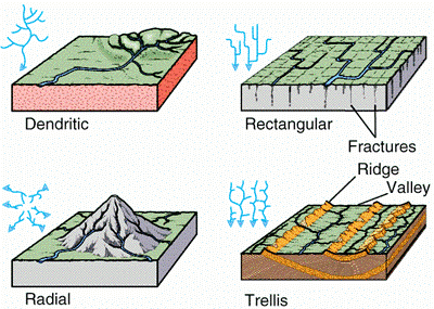
Dendritic Drainage Pattern:
- It resembles the branching pattern of tree roots.
- The Himalayan rivers are examples for this drainage pattern.
- It is developed in areas where the rock beneath the stream has no particular structure so it can be eroded equally easily in all directions.
- The tributaries join larger streams at acute angles.
 Incorrect
Solution (c)
Dendritic Drainage Pattern:
- It resembles the branching pattern of tree roots.
- The Himalayan rivers are examples for this drainage pattern.
- It is developed in areas where the rock beneath the stream has no particular structure so it can be eroded equally easily in all directions.
- The tributaries join larger streams at acute angles.
-
Question 5 of 35
5. Question
Match the following
Dam River 1. Thein a. Mahanadi 2. Hirakud b. Periyar 3. Salal c. Tapi 4. Kakrapara d. Chenab 5. Idukki e. Ravi Choose the correct code:
Correct
Solution (a)
Dam River 1. Thein a. Ravi 2. Hirakud b. Mahanadi 3. Salal c. Chenab 4. Kakrapara d. Tapi 5. Idukki e. Periyar Incorrect
Solution (a)
Dam River 1. Thein a. Ravi 2. Hirakud b. Mahanadi 3. Salal c. Chenab 4. Kakrapara d. Tapi 5. Idukki e. Periyar -
Question 6 of 35
6. Question
Consider the following statements about the Narmada River System
- It flows from east to west and drains into the Arabian Sea.
- It flows through the states of Madhya Pradesh, Andhra Pradesh, Gujarat, and Maharashtra.
Choose the correct code:
Correct
Solution (a)
Statement 1 Statement 2 Correct Incorrect The Narmada River System flows from east to west and drains into the Arabian Sea. The Tapti and the Mahi rivers also run from east to west.
It flows through the states of Madhya Pradesh, Gujarat, and Maharashtra. It rises to the summit of the Amarkantak Hill in Madhya Pradesh and outlines the traditional frontier between North India and South India.
Incorrect
Solution (a)
Statement 1 Statement 2 Correct Incorrect The Narmada River System flows from east to west and drains into the Arabian Sea. The Tapti and the Mahi rivers also run from east to west.
It flows through the states of Madhya Pradesh, Gujarat, and Maharashtra. It rises to the summit of the Amarkantak Hill in Madhya Pradesh and outlines the traditional frontier between North India and South India.
-
Question 7 of 35
7. Question
Jet Streams are high speed winds located in the upper troposphere. Consider the following statements
- Jet Streams are found in both the Northern and Southern Hemispheres.
- Polar front jet streams are closely related to tropical weather disturbances.
- Sub-Tropical Jet Streams are formed as warm air from the equator moves towards the poles.
How many of the above statements are correct?
Correct
Solution (b)
Statement 1 Statement2 Statement 3 Correct Incorrect Correct The Jet streams located in the upper troposphere (9 – 14 km) are bands of high-speed winds (95-190 km/hr). The two most important types of jet streams are the Polar Jet Streams and the Subtropical Jet Streams. They are found in both the Northern and Southern Hemispheres.
Polar Jet Streams are created when cold air from the Polar Regions meets warmer air from the equator. It is a fact that the so-called polar front jet streams are closely related to the middle latitude weather disturbances. It has no relation with the tropical areas and it is confined to the Frigid Zone. Sub-Tropical Jet Streams are formed as warm air from the equator moves towards the poles that form a steep temperature incline along a subtropical front. Incorrect
Solution (b)
Statement 1 Statement2 Statement 3 Correct Incorrect Correct The Jet streams located in the upper troposphere (9 – 14 km) are bands of high-speed winds (95-190 km/hr). The two most important types of jet streams are the Polar Jet Streams and the Subtropical Jet Streams. They are found in both the Northern and Southern Hemispheres.
Polar Jet Streams are created when cold air from the Polar Regions meets warmer air from the equator. It is a fact that the so-called polar front jet streams are closely related to the middle latitude weather disturbances. It has no relation with the tropical areas and it is confined to the Frigid Zone. Sub-Tropical Jet Streams are formed as warm air from the equator moves towards the poles that form a steep temperature incline along a subtropical front. -
Question 8 of 35
8. Question
Consider the Following statements regarding Equatorial Climate:
- Temperature is uniform throughout the year therefore Diurnal range of temperature is large.
- Cloudiness and heavy precipitation make the equatorial climate very humid and sticky.
Choose the correct code:
Correct
Solution (b)
Statement 1 Statement 2 Incorrect Correct The most outstanding feature of the equatorial climate is its great uniformity of temperature throughout the year therefore, the diurnal range of temperature is small. Precipitation is heavy between 60 inches and 100 inches and well distributed throughout the year. There is no month without rain. A distinct dry season like those of the Savanna or the Tropical Monsoon Climates is absent. The Cloudiness and heavy precipitation make relative humidity very high and thus, the climate becomes sticky and uncomfortable.
Incorrect
Solution (b)
Statement 1 Statement 2 Incorrect Correct The most outstanding feature of the equatorial climate is its great uniformity of temperature throughout the year therefore, the diurnal range of temperature is small. Precipitation is heavy between 60 inches and 100 inches and well distributed throughout the year. There is no month without rain. A distinct dry season like those of the Savanna or the Tropical Monsoon Climates is absent. The Cloudiness and heavy precipitation make relative humidity very high and thus, the climate becomes sticky and uncomfortable.
-
Question 9 of 35
9. Question
Consider the following statements about mountain climate and coastal climate?
- Unlike coastal climate, mountain climate does not witness much seasonal variation in a single year.
- Temperature inversion is more frequent in coastal climates than in mountain climates.
- Both types of climates are suitable for the growth of coniferous forests.
How many of the above statements are correct?
Correct
Solution (d)
Statement 1 Statement 2 Statement 3 Incorrect Incorrect Incorrect Unlike mountain climate, coastal climate does not witness much seasonal variation in a single year. This is because of the moderation of heat due to the presence of Oceans/seas. On the other hand, Mountain experiences several climatic phenomena like temperature inversion, Katabatic winds in the valleys, etc, and will witness different weather patterns. Temperature inversion is more frequent in the mountainous region because of katabatic winds. Temperature inversion is a reversal of the normal behavior of temperature in the troposphere (the region of the atmosphere nearest the Earth’s surface), in which a layer of cool air at the surface is overlain by a layer of warmer air. (Under normal conditions air temperature usually decreases with height). Coastal climates rarely favor the growth of coniferous forests. A coniferous forest is a terrestrial biome found in temperate regions of the world with warm summers and cool winters and adequate rainfall to sustain a forest. In most temperate coniferous forests, evergreen conifers predominate, while some are a mix of conifers and broad-leaf evergreen trees and/or broad-leaf deciduous trees.
Temperate evergreen forests are common in the United States of America, areas of regions that have mild winters and warm summers.
They have needle-pointed leaves that avoid the deposition of snow and help in the process of photosynthesis.
Incorrect
Solution (d)
Statement 1 Statement 2 Statement 3 Incorrect Incorrect Incorrect Unlike mountain climate, coastal climate does not witness much seasonal variation in a single year. This is because of the moderation of heat due to the presence of Oceans/seas. On the other hand, Mountain experiences several climatic phenomena like temperature inversion, Katabatic winds in the valleys, etc, and will witness different weather patterns. Temperature inversion is more frequent in the mountainous region because of katabatic winds. Temperature inversion is a reversal of the normal behavior of temperature in the troposphere (the region of the atmosphere nearest the Earth’s surface), in which a layer of cool air at the surface is overlain by a layer of warmer air. (Under normal conditions air temperature usually decreases with height). Coastal climates rarely favor the growth of coniferous forests. A coniferous forest is a terrestrial biome found in temperate regions of the world with warm summers and cool winters and adequate rainfall to sustain a forest. In most temperate coniferous forests, evergreen conifers predominate, while some are a mix of conifers and broad-leaf evergreen trees and/or broad-leaf deciduous trees.
Temperate evergreen forests are common in the United States of America, areas of regions that have mild winters and warm summers.
They have needle-pointed leaves that avoid the deposition of snow and help in the process of photosynthesis.
-
Question 10 of 35
10. Question
Consider the following pairs:
Type of climate Region
- China Type – South Eastern United States
- Gulf Type – Eastern Australia and Northern Argentina
- Natal Type – Southern Japan
How many of the above given pairs is/are correctly matched?
Correct
Solution (d)
Statement 1 Statement 2 Statement 3 Incorrect Incorrect Incorrect The China Type Central and North China (including southern Japan (temperate monsoonal).
The Gulf Type South-Eastern United States, (slight-monsoonal).
The Natal Type The entire warm temperate eastern margin (non-monsoonal areas) of the southern hemisphere includes Natal, eastern Australia, and southern Brazil-Paraguay- Uruguay and northern Argentina.
Incorrect
Solution (d)
Statement 1 Statement 2 Statement 3 Incorrect Incorrect Incorrect The China Type Central and North China (including southern Japan (temperate monsoonal).
The Gulf Type South-Eastern United States, (slight-monsoonal).
The Natal Type The entire warm temperate eastern margin (non-monsoonal areas) of the southern hemisphere includes Natal, eastern Australia, and southern Brazil-Paraguay- Uruguay and northern Argentina.
-
Question 11 of 35
11. Question
Consider the following statements about different Climatic regions of the world
- Savannah Climate is a transitional type of climate found between equatorial forests and trade wind hot deserts.
- Major Hot deserts of the world are located on the west coasts of continents between latitudes 30° and 45°.
- Mediterranean climate is characterized by a dry warm summer with onshore winds.
- Temperate grasslands are found in Sudan-type of climates.
How many of the above statements are correct?
Correct
Solution (a)
Statement 1 Statement 2 Statement 3 Statement 4 Correct Incorrect Incorrect Incorrect Savannah Climate is a transitional type of climate found between equatorial forests and trade wind hot deserts. Grasses and trees – The savanna is a rolling grassland with scattered trees and shrubs.
Rainy and dry seasons – Savannas have two distinct seasons in regard to precipitation. There is a rainy season in the summer with around 15 to 25 inches of rain and a dry season in the winter when only a couple of inches of rain may fall.
Large herds of animals – There are often large herds of grazing animals on the savanna that thrive on the abundance of grass and trees.
Warm – The savanna stays pretty warm all year. It cools down some during the dry season but stays warm and humid during the rainy season.
Major Hot deserts of the world are located on the west coasts of continents between latitudes 15° and 30°. It includes the Sahara Desert and the Great Australian Desert. The climate of these deserts is scorching hot and parched dry. It has a short rainy season. Since the sky is cloudless and clear, the rate of water evaporation is greater than the rate of water accumulation. Hence, there is water scarcity.
However, the nights may be freezing cold with temperatures nearing zero degrees
Celsius. Thus, there is a high diurnal range of temperature.
Mediterranean climate is characterized by a dry warm summer with offshore winds. Almost no rain falls during the summer, so most of the rain falls during the cooler winter. The summer experiences cold ocean currents that bring dry air and no precipitation.
During the winter the currents shift and warmer, moist air brings rain to these areas. Snow can fall in higher elevation areas or places that are farther north.
Mediterranean climates receive around 20 inches of annual(yearly) rainfall.
Temperate grasslands are found in the Temperate zone and not in the tropical zone. Sudan has tropical grasslands and not temperate grasslands. In Eurasia they are called the Steppes, in North America, they are called Prairies, in South America, they are called Pampas, in South Africa, they are called Velds
Incorrect
Solution (a)
Statement 1 Statement 2 Statement 3 Statement 4 Correct Incorrect Incorrect Incorrect Savannah Climate is a transitional type of climate found between equatorial forests and trade wind hot deserts. Grasses and trees – The savanna is a rolling grassland with scattered trees and shrubs.
Rainy and dry seasons – Savannas have two distinct seasons in regard to precipitation. There is a rainy season in the summer with around 15 to 25 inches of rain and a dry season in the winter when only a couple of inches of rain may fall.
Large herds of animals – There are often large herds of grazing animals on the savanna that thrive on the abundance of grass and trees.
Warm – The savanna stays pretty warm all year. It cools down some during the dry season but stays warm and humid during the rainy season.
Major Hot deserts of the world are located on the west coasts of continents between latitudes 15° and 30°. It includes the Sahara Desert and the Great Australian Desert. The climate of these deserts is scorching hot and parched dry. It has a short rainy season. Since the sky is cloudless and clear, the rate of water evaporation is greater than the rate of water accumulation. Hence, there is water scarcity.
However, the nights may be freezing cold with temperatures nearing zero degrees
Celsius. Thus, there is a high diurnal range of temperature.
Mediterranean climate is characterized by a dry warm summer with offshore winds. Almost no rain falls during the summer, so most of the rain falls during the cooler winter. The summer experiences cold ocean currents that bring dry air and no precipitation.
During the winter the currents shift and warmer, moist air brings rain to these areas. Snow can fall in higher elevation areas or places that are farther north.
Mediterranean climates receive around 20 inches of annual(yearly) rainfall.
Temperate grasslands are found in the Temperate zone and not in the tropical zone. Sudan has tropical grasslands and not temperate grasslands. In Eurasia they are called the Steppes, in North America, they are called Prairies, in South America, they are called Pampas, in South Africa, they are called Velds
-
Question 12 of 35
12. Question
Jet streams play an important role in:
- Monsoons
- Cyclones
- Anti-cyclones
- Heat balance
Which of the below option is/are correct?
Correct
Solution (d)
Jets streams play a key role in determining the weather because they usually separate colder air and warmer air. Jet streams generally push air masses around, moving weather systems to new areas and even causing them to stall if they have moved too far away
As jet streams impact changes in upper atmospheric circulations, they affect all the above phenomenon.
Incorrect
Solution (d)
Jets streams play a key role in determining the weather because they usually separate colder air and warmer air. Jet streams generally push air masses around, moving weather systems to new areas and even causing them to stall if they have moved too far away
As jet streams impact changes in upper atmospheric circulations, they affect all the above phenomenon.
-
Question 13 of 35
13. Question
Consider the following pairs concerning types of drainage patterns
- Trellis Pattern – It develops where hard and soft rocks exist parallel to each other.
- Rectangular Pattern – It develops when a stream flows in different directions from a central peak.
- Dendritic Pattern – The streams and tributaries’ development resemble the branches of a tree.
- Radial Pattern – It develops when there is an accumulation of streams to a central point from where the river flows downstream.
How many of the pair(s) given above is/are correct?
Correct
Solution (b)
Statement 1 Statement 2 Statement 3 Statement 4 Correct Incorrect Correct Incorrect Trellis Drainage Pattern: When a river is joined by its tributaries at almost right angles, it develops a trellis pattern. Trellis pattern develops where hard and soft rocks exist parallel to each other. Rectangular Drainage Pattern: When rocks are strongly joined, then a rectangular pattern develops. The rectangular drainage pattern is prevalent in faulted areas.
It grows on a rocky surface that is closely bound.
Streams take the path of least resistance; therefore, they congregate in areas with the weakest exposed rock.
The tributary streams bend sharply and enter the mainstream at a steep angle. E.g. Chambal, Betwa, and Ken are three streams found in the Vindhya mountain range.
Dendritic Drainage Pattern: When the river channel follows the slope of the terrain, it develops a dendritic pattern. The stream and its tributaries resemble the branches of a tree. Hence, it is called a dendritic pattern Radial Drainage Pattern: When the streams flow in different directions from a central peak or dome-like structure, a radial pattern is developed. The description given in the question matches the Centripetal system of drainage.
Incorrect
Solution (b)
Statement 1 Statement 2 Statement 3 Statement 4 Correct Incorrect Correct Incorrect Trellis Drainage Pattern: When a river is joined by its tributaries at almost right angles, it develops a trellis pattern. Trellis pattern develops where hard and soft rocks exist parallel to each other. Rectangular Drainage Pattern: When rocks are strongly joined, then a rectangular pattern develops. The rectangular drainage pattern is prevalent in faulted areas.
It grows on a rocky surface that is closely bound.
Streams take the path of least resistance; therefore, they congregate in areas with the weakest exposed rock.
The tributary streams bend sharply and enter the mainstream at a steep angle. E.g. Chambal, Betwa, and Ken are three streams found in the Vindhya mountain range.
Dendritic Drainage Pattern: When the river channel follows the slope of the terrain, it develops a dendritic pattern. The stream and its tributaries resemble the branches of a tree. Hence, it is called a dendritic pattern Radial Drainage Pattern: When the streams flow in different directions from a central peak or dome-like structure, a radial pattern is developed. The description given in the question matches the Centripetal system of drainage.
-
Question 14 of 35
14. Question
Which of the following rivers has its source of origin at/near the Manasarovar lake?
- Brahmaputra
- Indus
- Gandak
- Satluj
Select the correct answer using the codes given below
Correct
Solution (b)
Statement 1 Statement 2 Statement 3 Statement 4 Correct Correct Incorrect Correct The Brahmaputra rises in Tibet East of Mansarovar lake very close to the sources of the Indus and the Satluj. Originating from Chemyandung glacier It is slightly longer than the Indus, and most of its course lies outside India. It flows Eastwards parallel to the Himalayas. On reaching the Namcha Barwa (7757 m), it takes a ‘U-turn and enters India in Arunachal Pradesh through a gorge. Here, it is called the Dihang and it is joined by the Dibang, the Lohit, and many other tributaries to form the Brahmaputra in Assam. The river Indus rises in Tibet, near Lake Mansarovar originating from the single kanban glacier, it enters India in the Ladakh district of Jammu and Kashmir. Several tributaries, Zaskar, Nubra, Shyok, and Hunza, join it in the Kashmir region. The Gandak comprises two streams, namely Kali Gandaki and Trishul Ganga. It rises in Nepal The Himalayas between the Dhaulagiri and Mount Everest (not near the Mansarovar lake in Tibet) drain the central part of Nepal. It enters the Ganga plain in the Champaran district of Bihar and joins the Ganga at Sonpur near Patna The Satluj originates in the Rakas lake near Mansarovar at an altitude of 4,555 m in Tibet where it is known as Langchen Khambab. It flows almost parallel to the Indus for about 400 km before entering India and comes out of a gorge at Rupar. It passes through the Shipki La on the Himalayan ranges and enters the Punjab plains Incorrect
Solution (b)
Statement 1 Statement 2 Statement 3 Statement 4 Correct Correct Incorrect Correct The Brahmaputra rises in Tibet East of Mansarovar lake very close to the sources of the Indus and the Satluj. Originating from Chemyandung glacier It is slightly longer than the Indus, and most of its course lies outside India. It flows Eastwards parallel to the Himalayas. On reaching the Namcha Barwa (7757 m), it takes a ‘U-turn and enters India in Arunachal Pradesh through a gorge. Here, it is called the Dihang and it is joined by the Dibang, the Lohit, and many other tributaries to form the Brahmaputra in Assam. The river Indus rises in Tibet, near Lake Mansarovar originating from the single kanban glacier, it enters India in the Ladakh district of Jammu and Kashmir. Several tributaries, Zaskar, Nubra, Shyok, and Hunza, join it in the Kashmir region. The Gandak comprises two streams, namely Kali Gandaki and Trishul Ganga. It rises in Nepal The Himalayas between the Dhaulagiri and Mount Everest (not near the Mansarovar lake in Tibet) drain the central part of Nepal. It enters the Ganga plain in the Champaran district of Bihar and joins the Ganga at Sonpur near Patna The Satluj originates in the Rakas lake near Mansarovar at an altitude of 4,555 m in Tibet where it is known as Langchen Khambab. It flows almost parallel to the Indus for about 400 km before entering India and comes out of a gorge at Rupar. It passes through the Shipki La on the Himalayan ranges and enters the Punjab plains -
Question 15 of 35
15. Question
Consider the following statements concerning the Ganga River system
- The headwaters of the Ganga, called the ‘Alakananda’ is fed by the Gangotri Glacier
- At Haridwar, the Ganga emerges from the mountains and flows onto the plains
- River Yamuna, as a left bank tributary meets the Ganga at Allahabad (Prayagraj)
How many of the above statements are correct?
Correct
Solution (a)
Statement 1 Statement 2 Statement 3 Incorrect Correct Incorrect The headwaters of the Ganga called the ‘Bhagirathi’ (not Alaknanda) is fed by the Gangotri Glacier and joined by the Alaknanda at Devaprayag in Uttarakhand. At Haridwar, the Ganga emerges from the mountains onto the plains. The Ganga is joined by many tributaries from the Himalayas, a few of them being major rivers, such as the Yamuna, the Ghaghara, the Gandak, and the Kosi.
The river Yamuna rises from the Yamunotri Glacier in the Himalayas. It flows parallel to the Ganga and as a right-bank tributary (not a left-bank tributary) meets the Ganga at Allahabad. Incorrect
Solution (a)
Statement 1 Statement 2 Statement 3 Incorrect Correct Incorrect The headwaters of the Ganga called the ‘Bhagirathi’ (not Alaknanda) is fed by the Gangotri Glacier and joined by the Alaknanda at Devaprayag in Uttarakhand. At Haridwar, the Ganga emerges from the mountains onto the plains. The Ganga is joined by many tributaries from the Himalayas, a few of them being major rivers, such as the Yamuna, the Ghaghara, the Gandak, and the Kosi.
The river Yamuna rises from the Yamunotri Glacier in the Himalayas. It flows parallel to the Ganga and as a right-bank tributary (not a left-bank tributary) meets the Ganga at Allahabad. -
Question 16 of 35
16. Question
Consider the following pairs concerning rivers and the places where they originate
Rivers Source of origin
- The Krishna – Mahabaleshwar
- The Narmada – Chota Nagpur Plateau
- The Kaveri – Brahmagiri range
- The Mahanadi – Amarkantak hills
How many of the above pairs is/are incorrectly matched?
Correct
Solution (b)
Statement 1 Statement 2 Statement 3 Statement 4 Correct Incorrect Correct Incorrect The Krishna River: Rising from a spring near Mahabaleshwar, the Krishna flows for about 1400 km and Reaches the Bay of Bengal. The Tungabhadra, the Koyana, the Ghatprabha, the Musi, and the Bhima are some of its tributaries. The Narmada River: The Narmada rises in the Amarkantak hills (not in the Chota Nagpur plateau) in Madhya Pradesh. It flows towards the West in a rift valley formed due to faulting. On its way to the sea, the Narmada creates many picturesque locations. The ‘Marble rocks’, near Jabalpur, where the Narmada flows through a deep gorge, and the Dhuandhar falls, where the river plunges over steep rocks, are some of the notable ones The Kaveri River: It rises in the Brahmagiri range of the Western Ghats and it reaches the Bay of Bengal in the South of Cuddalore in Tamil Nadu. The total length of the river is about 760 km. Its main tributaries are Amravati, Bhavani, Hemavati, and Kabini. The Mahanadi River: The Mahanadi rises near Sihawa in the Raipur district of Chhattisgarh and runs through Odisha to discharge its water into the Bay of Bengal. It is 851 km long and its catchment area spreads over 1.42 lakh sq. km Incorrect
Solution (b)
Statement 1 Statement 2 Statement 3 Statement 4 Correct Incorrect Correct Incorrect The Krishna River: Rising from a spring near Mahabaleshwar, the Krishna flows for about 1400 km and Reaches the Bay of Bengal. The Tungabhadra, the Koyana, the Ghatprabha, the Musi, and the Bhima are some of its tributaries. The Narmada River: The Narmada rises in the Amarkantak hills (not in the Chota Nagpur plateau) in Madhya Pradesh. It flows towards the West in a rift valley formed due to faulting. On its way to the sea, the Narmada creates many picturesque locations. The ‘Marble rocks’, near Jabalpur, where the Narmada flows through a deep gorge, and the Dhuandhar falls, where the river plunges over steep rocks, are some of the notable ones The Kaveri River: It rises in the Brahmagiri range of the Western Ghats and it reaches the Bay of Bengal in the South of Cuddalore in Tamil Nadu. The total length of the river is about 760 km. Its main tributaries are Amravati, Bhavani, Hemavati, and Kabini. The Mahanadi River: The Mahanadi rises near Sihawa in the Raipur district of Chhattisgarh and runs through Odisha to discharge its water into the Bay of Bengal. It is 851 km long and its catchment area spreads over 1.42 lakh sq. km -
Question 17 of 35
17. Question
Which of the following is/are the tributaries of river Godavari?
- Koyana
- Manjra
- Penganga
- Pranhita
- Bhima
Select the correct answer using the codes given below
Correct
Solution (d)
Statement 1 Statement 2 Statement 3 Statement 4 Statement 5 Incorrect Correct Correct Correct Incorrect The Koyana is are the tributary of the river Krishna. Unlike most of the other rivers in Maharashtra which flow East-West direction, the Koyna river flows in a North-South direction. The Koyna River is famous for the Koyna Dam and the Koyna Hydroelectric Project.
The Manjari, also spelled Manjara or Manjeera, is a tributary of the river Godavari. It passes through the states of Maharashtra, Karnataka, and Telangana. It originates in the Balaghat range of hills near Ahmednagar district at an altitude of 823 meters and empties into the Godavari River. It is one of the tributaries of Godavari. The Painganga River (also known as the Penganga River) is the chief river of the Buldhana district, Hingoli district, Nanded district, Yavatmal district, Chandrapur district, and Washim district in the Maharashtra state in India. The Piranha River is the largest tributary of the Godavari River covering about 34% of its drainage basin conveying the combined waters of the Penganga River, the Wardha River, and the Wainganga River Bhima is the tributary of the river Krishna. It originates near Bhimashankar Temple in the Bhimashankar hills in the Taluka on the western side of the Western Ghats.
Incorrect
Solution (d)
Statement 1 Statement 2 Statement 3 Statement 4 Statement 5 Incorrect Correct Correct Correct Incorrect The Koyana is are the tributary of the river Krishna. Unlike most of the other rivers in Maharashtra which flow East-West direction, the Koyna river flows in a North-South direction. The Koyna River is famous for the Koyna Dam and the Koyna Hydroelectric Project.
The Manjari, also spelled Manjara or Manjeera, is a tributary of the river Godavari. It passes through the states of Maharashtra, Karnataka, and Telangana. It originates in the Balaghat range of hills near Ahmednagar district at an altitude of 823 meters and empties into the Godavari River. It is one of the tributaries of Godavari. The Painganga River (also known as the Penganga River) is the chief river of the Buldhana district, Hingoli district, Nanded district, Yavatmal district, Chandrapur district, and Washim district in the Maharashtra state in India. The Piranha River is the largest tributary of the Godavari River covering about 34% of its drainage basin conveying the combined waters of the Penganga River, the Wardha River, and the Wainganga River Bhima is the tributary of the river Krishna. It originates near Bhimashankar Temple in the Bhimashankar hills in the Taluka on the western side of the Western Ghats.
-
Question 18 of 35
18. Question
Consider the following pairs on Dams and associated Rivers
Multipurpose river valley projects Rivers associated
- Hirakud project – Mahanadi
- Bhakra-Nangal project – Beas
- Gandhi Sagar project – Chambal
- Nagarjuna Sagar project – Godavari
Which of the codes is/are correctly matched?
Correct
Solution (b)
Statement 1 Statement 2 Statement 3 Statement 4 Correct Incorrect Correct Incorrect Hirakud Dam is built across the Mahanadi River, about 15 kilometers from Sambalpur in the state of Odisha in India. It is one of the first major multipurpose river valley projects that started after India’s independence. It is India’s largest dam. The dam helps control floods in the Mahanadi delta and irrigates 75,000 km2 of land. The Bhakra-Nangal multipurpose dams are located in the state of Himachal Pradesh and are named after the two dams built at Bhakra and Nangal on the Satluj River (not beas river). The project comprises (i) two dams at Bhakra and Nangal (ii) powerhouses with a combined installed capacity of 1,204 megawatts (M.W.) and (iii) a Bhakra canal system for irrigation The Gandhi Sagar Dam is one of the four major dams built on India’s Chambal River. The dam is located in the state of Madhya Pradesh. It is a masonry gravity dam standing 62.17 meters high ⮚ The dam sports a total energy generation of about 564 GWh. The water released after power generation
is used for the irrigation of 427,000 hectares by the Kota Barrage
Nagarjuna Sagar Dam is a masonry dam across the Krishna River (not the Godavari River). The dam created a water reservoir with a gross storage capacity of 11.472 billion cubic meters. The dam is 590 feet tall from its deepest foundation and 0.99 miles long with 26 floodgates Incorrect
Solution (b)
Statement 1 Statement 2 Statement 3 Statement 4 Correct Incorrect Correct Incorrect Hirakud Dam is built across the Mahanadi River, about 15 kilometers from Sambalpur in the state of Odisha in India. It is one of the first major multipurpose river valley projects that started after India’s independence. It is India’s largest dam. The dam helps control floods in the Mahanadi delta and irrigates 75,000 km2 of land. The Bhakra-Nangal multipurpose dams are located in the state of Himachal Pradesh and are named after the two dams built at Bhakra and Nangal on the Satluj River (not beas river). The project comprises (i) two dams at Bhakra and Nangal (ii) powerhouses with a combined installed capacity of 1,204 megawatts (M.W.) and (iii) a Bhakra canal system for irrigation The Gandhi Sagar Dam is one of the four major dams built on India’s Chambal River. The dam is located in the state of Madhya Pradesh. It is a masonry gravity dam standing 62.17 meters high ⮚ The dam sports a total energy generation of about 564 GWh. The water released after power generation
is used for the irrigation of 427,000 hectares by the Kota Barrage
Nagarjuna Sagar Dam is a masonry dam across the Krishna River (not the Godavari River). The dam created a water reservoir with a gross storage capacity of 11.472 billion cubic meters. The dam is 590 feet tall from its deepest foundation and 0.99 miles long with 26 floodgates -
Question 19 of 35
19. Question
Identify the river having the following characteristics:
- It is the largest west flowing river of Peninsular India.
- It drains in the Gulf of Khambhat into the Arabian Sea.
- Its valley is a depressed block of the Earth’s crust bordered by parallel faults.
Which of the following rivers best describes the above characteristics?
Correct
Solution (a)
Statement 1 Statement 2 Statement 3 Statement 4 Correct Incorrect Incorrect Incorrect The Narmada originates on the western flank of the Amarkantak plateau at a height of about 1,057 m. It is the largest west-flowing river in Peninsular India. Flowing in a rift valley between the Satpura in the south and the Vindhyan range in the north, it forms a picturesque gorge in marble rocks and the Dhuandhar waterfall near Jabalpur. Its valley is a depressed block of the Earth’s crust bordered by parallel faults. After flowing a distance of about 1,312 km, it meets the Arabian sea south of Bharuch, forming a broad 27 km long estuary. Its catchment area is about 98,796 sq. km.
The Sardar Sarovar Project has been constructed on this river
The Son is a Larges south bank tributary of the Ganga, originating in the Amarkantak plateau. After forming a series of waterfalls at the edge of the plateau, it reaches Arrah, west of Patna, to join the Ganga.
Johilla River It is a tributary of River Son. Its source is near Amarkantak. Tapi River The Tapi is the other important westward-flowing river. It originates from Multai in the Betul district of Madhya Pradesh. Nearly 79 percent of its basin lies in Maharashtra, 15 percent in Madhya Pradesh, and the remaining 6 percent in Gujarat.
Incorrect
Solution (a)
Statement 1 Statement 2 Statement 3 Statement 4 Correct Incorrect Incorrect Incorrect The Narmada originates on the western flank of the Amarkantak plateau at a height of about 1,057 m. It is the largest west-flowing river in Peninsular India. Flowing in a rift valley between the Satpura in the south and the Vindhyan range in the north, it forms a picturesque gorge in marble rocks and the Dhuandhar waterfall near Jabalpur. Its valley is a depressed block of the Earth’s crust bordered by parallel faults. After flowing a distance of about 1,312 km, it meets the Arabian sea south of Bharuch, forming a broad 27 km long estuary. Its catchment area is about 98,796 sq. km.
The Sardar Sarovar Project has been constructed on this river
The Son is a Larges south bank tributary of the Ganga, originating in the Amarkantak plateau. After forming a series of waterfalls at the edge of the plateau, it reaches Arrah, west of Patna, to join the Ganga.
Johilla River It is a tributary of River Son. Its source is near Amarkantak. Tapi River The Tapi is the other important westward-flowing river. It originates from Multai in the Betul district of Madhya Pradesh. Nearly 79 percent of its basin lies in Maharashtra, 15 percent in Madhya Pradesh, and the remaining 6 percent in Gujarat.
-
Question 20 of 35
20. Question
Which of the following are west flowing rivers?
- Mahi
- Narmada
- Periyar
- Subarnarekha
Select the correct answer using the code given below.
Correct
Solution (b)
Statement 1 Statement 2 Statement 3 Statement 4 Correct Correct Correct Incorrect The Mahi is a river in western India. It rises in Madhya Pradesh and, after flowing through the Vagad region of Rajasthan, enters Gujarat and flows into the Arabian Sea. It is thus a west-flowing river. The Narmada River rises from the Amarkantak Plateau in Anuppur district Madhya Pradesh. It forms the traditional boundary between North India and South India and flows westwards over a length of before draining through the Gulf of Khambhat into the Arabian Sea Peryar origiantes from western ghats and flows into the Arabian Sea. Periyar is named the “Lifeline of Kerala” and is a west flowing river Subarnarekha is an east flowing river which drains into the Bay of Bengal. Major Rivers of the Peninsular Region – Most of the major Peninsular rivers except Narmada and Tapi flow from west to east. The other major river systems of the Peninsular drainage are – the Mahanadi the Godavari, the Krishna and the Kaveri; they all flow towards the east and fall into the Bay of Bengal.
Small Rivers of the Peninsular Region –
Flowing towards the west – Sabarmati, Mahi, Dhandhar, Kalindi, Sharavati, Bharathapuzha and Periyar.
Flowing towards the east – The Subarnrekha, the Baitarni, the Brahmani, the Vamsadhara, the Penner, the Palar and the Vaigai are important east flowing small rivers
Incorrect
Solution (b)
Statement 1 Statement 2 Statement 3 Statement 4 Correct Correct Correct Incorrect The Mahi is a river in western India. It rises in Madhya Pradesh and, after flowing through the Vagad region of Rajasthan, enters Gujarat and flows into the Arabian Sea. It is thus a west-flowing river. The Narmada River rises from the Amarkantak Plateau in Anuppur district Madhya Pradesh. It forms the traditional boundary between North India and South India and flows westwards over a length of before draining through the Gulf of Khambhat into the Arabian Sea Peryar origiantes from western ghats and flows into the Arabian Sea. Periyar is named the “Lifeline of Kerala” and is a west flowing river Subarnarekha is an east flowing river which drains into the Bay of Bengal. Major Rivers of the Peninsular Region – Most of the major Peninsular rivers except Narmada and Tapi flow from west to east. The other major river systems of the Peninsular drainage are – the Mahanadi the Godavari, the Krishna and the Kaveri; they all flow towards the east and fall into the Bay of Bengal.
Small Rivers of the Peninsular Region –
Flowing towards the west – Sabarmati, Mahi, Dhandhar, Kalindi, Sharavati, Bharathapuzha and Periyar.
Flowing towards the east – The Subarnrekha, the Baitarni, the Brahmani, the Vamsadhara, the Penner, the Palar and the Vaigai are important east flowing small rivers
-
Question 21 of 35
21. Question
It is a sacred river of southern India. It rises on Brahmagiri Hill of the Western Ghats and descends the Eastern Ghats in a series of great falls and drains into the Bay of Bengal. Its tributaries are Arkavathi, Hemavathi, Lakshmana Theertha, Shimsa, Kabini, and Harangi. It is known as Ponni, the Ganga of the south, and it is the fourth largest river in southern India.
The above paragraph refers to which of the following rivers?
Correct
Solution (b)
River Kaveri is a sacred river of southern India. It rises on Brahmagiri Hill of the Western Ghats and descends the Eastern Ghats in a series of great falls and drains into the Bay of Bengal. Its tributaries are Arkavathi, Hemavathi, Lakshmana Theertha, Shimsa, Kabini, and Harangi. It is known as Ponni, the Ganga of the south, and it is the fourth largest river in southern India. Hence option b is correct.
Incorrect
Solution (b)
River Kaveri is a sacred river of southern India. It rises on Brahmagiri Hill of the Western Ghats and descends the Eastern Ghats in a series of great falls and drains into the Bay of Bengal. Its tributaries are Arkavathi, Hemavathi, Lakshmana Theertha, Shimsa, Kabini, and Harangi. It is known as Ponni, the Ganga of the south, and it is the fourth largest river in southern India. Hence option b is correct.
-
Question 22 of 35
22. Question
Which of the following are part of the Climate Polycrisis?
- Rising temperatures
- Escalating sea-levels
- Increased extreme weather events
How many of the above statements are correct?
Correct
Solution (c)
The Climate Polycrisis, a term highlighted by Adam Tooze, represents multiple, interconnected crises stemming from climate change, affecting numerous sectors globally and in India. This involves rising temperatures, escalating sea levels, and increased extreme weather events, which individually and collectively pose challenges across various domains. Various sectors like energy, infrastructure, health, migration, and food production in India are intricately linked and impacted by climate change, necessitating comprehensive and interconnected solutions. Addressing the polycrisis requires a holistic strategy that considers all physical impacts and the resulting socio-economic challenges, ensuring solutions are resilient, equitable, and just across all sectors. Hence option c is correct.
Incorrect
Solution (c)
The Climate Polycrisis, a term highlighted by Adam Tooze, represents multiple, interconnected crises stemming from climate change, affecting numerous sectors globally and in India. This involves rising temperatures, escalating sea levels, and increased extreme weather events, which individually and collectively pose challenges across various domains. Various sectors like energy, infrastructure, health, migration, and food production in India are intricately linked and impacted by climate change, necessitating comprehensive and interconnected solutions. Addressing the polycrisis requires a holistic strategy that considers all physical impacts and the resulting socio-economic challenges, ensuring solutions are resilient, equitable, and just across all sectors. Hence option c is correct.
-
Question 23 of 35
23. Question
Consider the following statements about the International Coral Reef Initiative (ICRI)
- It was founded by Australia, France, Japan, Jamaica, the Philippines, Sweden, the United Kingdom, and the United States of America.
- It is a global partnership between nations and organizations that strives to preserve coral reefs and related ecosystems around the world.
- It was announced at the First Conference of the Parties of the Convention on Biological Diversity in December 1994.
How many of the above statements are correct?
Correct
Solution (c)
- The International Coral Reef Initiative (ICRI) was founded by Australia, France, Japan, Jamaica, the Philippines, Sweden, the United Kingdom, and the United States of America. Hence statement 1 is correct.
- Now, it has 45 countries as its members including India.
- It is a global partnership between nations and organizations that strives to preserve coral reefs and related ecosystems around the world. Hence statement 2 is correct.
- It is an informal group whose decisions are not binding on its members. However, its actions have been pivotal in continuing to highlight globally the importance of coral reefs and related ecosystems to environmental sustainability, food security, and social and cultural well-being.
- It was announced at the First Conference of the Parties of the Convention on Biological Diversity in December 1994 and at the high-level segment of the Intersessional Meeting of the U.N. Commission on Sustainable Development in April 1995. Hence statement 3 is correct.
Note: The Coral Reef Breakthrough Initiative was launched by the International Coral Reef Initiative (ICRI) in partnership with the Global Fund for Coral Reefs(GFCR) and the High-Level Climate Champions(HLCC). It aims to secure the future of at least 125,000 km2 of shallow-water tropical coral reefs with investments of at least US$12 billion to support the resilience of more than half a billion people globally by 2030.
Incorrect
Solution (c)
- The International Coral Reef Initiative (ICRI) was founded by Australia, France, Japan, Jamaica, the Philippines, Sweden, the United Kingdom, and the United States of America. Hence statement 1 is correct.
- Now, it has 45 countries as its members including India.
- It is a global partnership between nations and organizations that strives to preserve coral reefs and related ecosystems around the world. Hence statement 2 is correct.
- It is an informal group whose decisions are not binding on its members. However, its actions have been pivotal in continuing to highlight globally the importance of coral reefs and related ecosystems to environmental sustainability, food security, and social and cultural well-being.
- It was announced at the First Conference of the Parties of the Convention on Biological Diversity in December 1994 and at the high-level segment of the Intersessional Meeting of the U.N. Commission on Sustainable Development in April 1995. Hence statement 3 is correct.
Note: The Coral Reef Breakthrough Initiative was launched by the International Coral Reef Initiative (ICRI) in partnership with the Global Fund for Coral Reefs(GFCR) and the High-Level Climate Champions(HLCC). It aims to secure the future of at least 125,000 km2 of shallow-water tropical coral reefs with investments of at least US$12 billion to support the resilience of more than half a billion people globally by 2030.
-
Question 24 of 35
24. Question
Consider the following statements:
- The Indian Coast Guard (ICG) was established by the Coast Guard Act of 1978 as an independent armed force of India.
- The blueprint for a multidimensional Coast Guard was conceived by the visionary Rustamji Committee.
- The Indian Coast Guard (ICG) is the largest in the world and operates under the Ministry of Ports, Shipping, and Waterway.
How many of the above statements are correct?
Correct
Solution (b)
- The Indian Coast Guard (ICG) was established by the Coast Guard Act of 1978 as an independent armed force of India. Hence statement 1 is correct.
- It is headquartered in New Delhi.
- The blueprint for a multidimensional Coast Guard was conceived by the visionary Rustamji Committee. Hence statement 2 is correct.
- The Indian Coast Guard (ICG) is the fourth largest Coast Guard in the world and operates under the Department of Defence of the Union Ministry of Defence. Hence statement 3 is incorrect.
- For effective command and control, the Maritime Zones of India are divided into five Coast Guard Regions, namely, North-West, West, East, North-East and Andaman & Nicobar, with the respective Regional Headquarters located at Gandhinagar, Mumbai, Chennai, Kolkata and Port Blair.
Incorrect
Solution (b)
- The Indian Coast Guard (ICG) was established by the Coast Guard Act of 1978 as an independent armed force of India. Hence statement 1 is correct.
- It is headquartered in New Delhi.
- The blueprint for a multidimensional Coast Guard was conceived by the visionary Rustamji Committee. Hence statement 2 is correct.
- The Indian Coast Guard (ICG) is the fourth largest Coast Guard in the world and operates under the Department of Defence of the Union Ministry of Defence. Hence statement 3 is incorrect.
- For effective command and control, the Maritime Zones of India are divided into five Coast Guard Regions, namely, North-West, West, East, North-East and Andaman & Nicobar, with the respective Regional Headquarters located at Gandhinagar, Mumbai, Chennai, Kolkata and Port Blair.
-
Question 25 of 35
25. Question
Consider the following statements:
- The National Turmeric Board shall have a Chairperson to be appointed by the Ministry of Commerce and Industry.
- India is the largest producer, consumer, and exporter of turmeric in the world.
- The leading export markets for Indian Turmeric are Bangladesh, UAE, USA, and Malaysia.
How many of the above statements are correct?
Correct
Solution (b)
- The National Turmeric Board shall have a Chairperson to be appointed by the Central Government. Hence statement 1 is incorrect.
- It aims to focus on the development and growth of turmeric and turmeric products in the country.
- It will have members from the Ministry of AYUSH, Departments of Pharmaceuticals, Agriculture & Farmers Welfare, Commerce & Industry of the Union Government, senior State Government representatives from three states (on a rotation basis), select national/state institutions involved in research, representatives of turmeric farmers and exporters.
- India is the largest producer, consumer, and exporter of turmeric in the world. Hence statement 2 is correct.
- More than 30 varieties of Turmeric are grown in India and it is grown in over 20 states in the country. The largest producing states of Turmeric are Maharashtra, Telangana, Karnataka, and Tamil Nadu.
The leading export markets for Indian Turmeric are Bangladesh, UAE, USA, and Malaysia. Hence statement 3 is correct.
Incorrect
Solution (b)
- The National Turmeric Board shall have a Chairperson to be appointed by the Central Government. Hence statement 1 is incorrect.
- It aims to focus on the development and growth of turmeric and turmeric products in the country.
- It will have members from the Ministry of AYUSH, Departments of Pharmaceuticals, Agriculture & Farmers Welfare, Commerce & Industry of the Union Government, senior State Government representatives from three states (on a rotation basis), select national/state institutions involved in research, representatives of turmeric farmers and exporters.
- India is the largest producer, consumer, and exporter of turmeric in the world. Hence statement 2 is correct.
- More than 30 varieties of Turmeric are grown in India and it is grown in over 20 states in the country. The largest producing states of Turmeric are Maharashtra, Telangana, Karnataka, and Tamil Nadu.
The leading export markets for Indian Turmeric are Bangladesh, UAE, USA, and Malaysia. Hence statement 3 is correct.
-
Question 26 of 35
26. Question
Consider the following statements about the India-Japan Fund (IJF)
- It is the first bi-lateral fund of the National Investment and Infrastructure Fund (NIIF).
- It will focus on investing in environmental sustainability and low-carbon emission strategies.
Choose the correct code:
Correct
Solution (c)
- The India-Japan Fund (IJF) is the first bilateral fund of the National Investment and Infrastructure Fund (NIIF). Hence statement 1 is correct.
- It was launched by the National Investment and Infrastructure Fund (NIIF) in collaboration with the Japan Bank for International Cooperation(JBIC).
- It is managed by NIIF Limited (NIIFL) and JBIC IG (a subsidiary of JBIC).
- The Government of India (GoI) will contribute 49% of the target corpus and the remaining 51% will be contributed by JBIC.
- It will focus on investing in environmental sustainability and low-carbon emission strategies. Hence statement 2 is correct.
- It aims to play the role of being a ‘partner of choice’ to further enhance Japanese investments in India.
Incorrect
Solution (c)
- The India-Japan Fund (IJF) is the first bilateral fund of the National Investment and Infrastructure Fund (NIIF). Hence statement 1 is correct.
- It was launched by the National Investment and Infrastructure Fund (NIIF) in collaboration with the Japan Bank for International Cooperation(JBIC).
- It is managed by NIIF Limited (NIIFL) and JBIC IG (a subsidiary of JBIC).
- The Government of India (GoI) will contribute 49% of the target corpus and the remaining 51% will be contributed by JBIC.
- It will focus on investing in environmental sustainability and low-carbon emission strategies. Hence statement 2 is correct.
- It aims to play the role of being a ‘partner of choice’ to further enhance Japanese investments in India.
-
Question 27 of 35
27. Question
Which of the following are the applications of Quantum Dots?
- It can be used as a security marker on currency and documents to prevent counterfeiting.
- It helps in targeted drug delivery for certain cancer treatments and nanomedicine.
- It serve as bright fluorescent markers for tagging and tracking various objects.
- It helps to improve the efficiency of solar panels by helping them absorb and convert sunlight into electricity.
How many of the above statements are correct?
Correct
Solution (d)
Quantum dots are particles that are a few nanometres wide. They exhibit unique optical properties due to their small physical size.
The applications of Quantum Dots:
- It can be used as a security marker on currency and documents to prevent counterfeiting. Hence statement 1 is correct.
- It helps in targeted drug delivery for certain cancer treatments and nanomedicine. Hence statement 2 is correct.
- It serve as bright fluorescent markers for tagging and tracking various objects. Hence statement 3 is correct.
- It helps to improve the efficiency of solar panels by helping them absorb and convert sunlight into electricity. Hence statement 4 is correct.
- It can be explored as potential qubits or quantum bits for use in quantum computing due to their quantum mechanical properties.
- It makes computer monitors and TV screens more colourful and brighter.
Note: The 2023 Nobel Prize in chemistry was awarded to Moungi G. Bawendi, Louis E. Brus, and Alexei I. Ekimov for the discovery and synthesis of quantum dots.
Incorrect
Solution (d)
Quantum dots are particles that are a few nanometres wide. They exhibit unique optical properties due to their small physical size.
The applications of Quantum Dots:
- It can be used as a security marker on currency and documents to prevent counterfeiting. Hence statement 1 is correct.
- It helps in targeted drug delivery for certain cancer treatments and nanomedicine. Hence statement 2 is correct.
- It serve as bright fluorescent markers for tagging and tracking various objects. Hence statement 3 is correct.
- It helps to improve the efficiency of solar panels by helping them absorb and convert sunlight into electricity. Hence statement 4 is correct.
- It can be explored as potential qubits or quantum bits for use in quantum computing due to their quantum mechanical properties.
- It makes computer monitors and TV screens more colourful and brighter.
Note: The 2023 Nobel Prize in chemistry was awarded to Moungi G. Bawendi, Louis E. Brus, and Alexei I. Ekimov for the discovery and synthesis of quantum dots.
-
Question 28 of 35
28. Question
In which of the following country Mission Operation Cactus was led by the Indian Armed Forces in 1988?
Correct
Solution (b)
Mission Operation Cactus was led by the Indian Armed Forces in 1988 in Maldives. It was a successful mission to prevent a coup attempt which was against the Maldivian Government headed by President Abdul Gayoom. Hence option b is correct.
Incorrect
Solution (b)
Mission Operation Cactus was led by the Indian Armed Forces in 1988 in Maldives. It was a successful mission to prevent a coup attempt which was against the Maldivian Government headed by President Abdul Gayoom. Hence option b is correct.
-
Question 29 of 35
29. Question
Which of the following has got geographical indication from Jammu and Kashmir?
- Basohli Pashmina
- Kinnaur Shawl
- Kalari
Choose the correct code:
Correct
Solution (b)
The GI tags in the Union territory of Jammu and Kashmir:
Geographical Indications Category Gucchi mushroom Agriculture Kani shawl Handicraft Kashmiri hand-knotted carpet Handicraft Kashmir paper mache Handicraft Kashmir Pashmina Handicraft Kashmir sozani craft Handicraft Kashmir walnut wood carving Handicraft Kashmir saffron Agriculture Khatamband Handicraft Note:
- Recently, Basohli Pashmina and Kalari were given the GI tag from Jammu and Kashmir.
- Basohli Pashmina is a more than 100-year-old traditional craft from Jammu and Kashmir’s Kathua district. It is a hand-spun product known for extreme softness, fineness, and lightweightness.
- Kalari is a Dogra cuisine. The dish finds its origin in Udhampur district, J&K. It is made from milk and is a dense cheese. It’s cooked in its fat, salted, and served hot with bun slices.
- Kinnaur Shawl belongs to the State of Himachal Pradesh
Hence option b is correct.
Incorrect
Solution (b)
The GI tags in the Union territory of Jammu and Kashmir:
Geographical Indications Category Gucchi mushroom Agriculture Kani shawl Handicraft Kashmiri hand-knotted carpet Handicraft Kashmir paper mache Handicraft Kashmir Pashmina Handicraft Kashmir sozani craft Handicraft Kashmir walnut wood carving Handicraft Kashmir saffron Agriculture Khatamband Handicraft Note:
- Recently, Basohli Pashmina and Kalari were given the GI tag from Jammu and Kashmir.
- Basohli Pashmina is a more than 100-year-old traditional craft from Jammu and Kashmir’s Kathua district. It is a hand-spun product known for extreme softness, fineness, and lightweightness.
- Kalari is a Dogra cuisine. The dish finds its origin in Udhampur district, J&K. It is made from milk and is a dense cheese. It’s cooked in its fat, salted, and served hot with bun slices.
- Kinnaur Shawl belongs to the State of Himachal Pradesh
Hence option b is correct.
-
Question 30 of 35
30. Question
Consider the following statements about Bekal Fort
- It appears to emerge from the sea and is the largest fort in Karnataka.
- It was built in the 17th century by Shivappa Nayaka of the Keladi dynasty.
- In the fort, the water tank and steps leading to an observation tower built by Tipu Sultan.
How many of the above statements are correct?
Correct
Solution (b)
- Bekal Fort appears to emerge from the sea and is the largest fort in Kerala. Hence statement 1 is incorrect.
- The fort’s solid construction resembles the Thalassery Fort and the St. Angelo Fort at Kannur built by the Dutch.
- It was built in the 17th century by Shivappa Nayaka of the Keladi dynasty. Hence statement 2 is correct.
- The fort has seen the rise and fall of several dynasties and later came under the control of the Kingdom of Mysore.
- In the fort, the water tank and steps leading to an observation tower built by Tipu Sultan. Hence statement 3 is correct.
- The fort’s zigzag entrance and surrounding trenches reveal its defensive strategy. Holes on the outer walls are designed to defend the fort effectively from naval attacks. The upper holes are meant for aiming at the farthest targets; the lower holes below are for striking as enemy nearer and the lowest holes to attacking the enemy closest to the fort.
Incorrect
Solution (b)
- Bekal Fort appears to emerge from the sea and is the largest fort in Kerala. Hence statement 1 is incorrect.
- The fort’s solid construction resembles the Thalassery Fort and the St. Angelo Fort at Kannur built by the Dutch.
- It was built in the 17th century by Shivappa Nayaka of the Keladi dynasty. Hence statement 2 is correct.
- The fort has seen the rise and fall of several dynasties and later came under the control of the Kingdom of Mysore.
- In the fort, the water tank and steps leading to an observation tower built by Tipu Sultan. Hence statement 3 is correct.
- The fort’s zigzag entrance and surrounding trenches reveal its defensive strategy. Holes on the outer walls are designed to defend the fort effectively from naval attacks. The upper holes are meant for aiming at the farthest targets; the lower holes below are for striking as enemy nearer and the lowest holes to attacking the enemy closest to the fort.
-
Question 31 of 35
31. Question
A person walks a certain distance and rides back in 61⁄2 hours. If he walks both ways, the time taken is 7(3⁄4) hours. How long would it take if he rides both ways?
Correct
Solution (b)
= W + R = 13/2 ……. (i)
= W + W = 31/4 ……. (ii)
= 2W = 31/4 or W = 31/8
Putting W = 31/8 in equation (i) above
31/8 + R = 13/2
R = 13/2 – 31/8 = (52 – 31)/8 = 21/8
Therefore, 2 R = 2 ×21/8 = 21/4 = 51⁄4 hours = 5 hours 15 minutes
Incorrect
Solution (b)
= W + R = 13/2 ……. (i)
= W + W = 31/4 ……. (ii)
= 2W = 31/4 or W = 31/8
Putting W = 31/8 in equation (i) above
31/8 + R = 13/2
R = 13/2 – 31/8 = (52 – 31)/8 = 21/8
Therefore, 2 R = 2 ×21/8 = 21/4 = 51⁄4 hours = 5 hours 15 minutes
-
Question 32 of 35
32. Question
In a test, 3 marks are given for each correct answer and 2 marks are cut for each wrong answer. In that test of 50 questions, a student got 60 marks. How many questions did he solve correctly?
Correct
Solution (c)
Let the number of correct questions be ‘x’
Then, wrong questions is “(50-x)”
Therefore, 3x – 2 (50-x) = 60
3x – 100 + 2x = 60 => 5x = 160 => x = 32
Incorrect
Solution (c)
Let the number of correct questions be ‘x’
Then, wrong questions is “(50-x)”
Therefore, 3x – 2 (50-x) = 60
3x – 100 + 2x = 60 => 5x = 160 => x = 32
-
Question 33 of 35
33. Question
In a group of persons, 60% of the persons are male and 40% of the persons are married. If two-fifth of the males are married, what fraction of the females is single?
Correct
Solution (b)
Let the no. of total persons = 100
Number of male = 60
∴ No. of female = 100 – 60 = 40
∴ Total married male = (2/5) * 60 = 24
∴ Married female = 40 – 24 = 16
Now, unmarried female = 40 – 16 = 24
∴ Required fraction = 24/40 = 3/5
Incorrect
Solution (b)
Let the no. of total persons = 100
Number of male = 60
∴ No. of female = 100 – 60 = 40
∴ Total married male = (2/5) * 60 = 24
∴ Married female = 40 – 24 = 16
Now, unmarried female = 40 – 16 = 24
∴ Required fraction = 24/40 = 3/5
-
Question 34 of 35
34. Question
The least number which must be added to the greatest number of 4 digits in order that the sum may be exactly divisible by 307 is
Correct
Solution (d)
On dividing 9999 by 307, we get remainder 175.
Therefore, least number which must be added to 9999 to get a number perfectly divisible by 307
= 307 – 175 = 132.
Incorrect
Solution (d)
On dividing 9999 by 307, we get remainder 175.
Therefore, least number which must be added to 9999 to get a number perfectly divisible by 307
= 307 – 175 = 132.
-
Question 35 of 35
35. Question
The average height of 40 students is 163 cm. On a particular day three students A, B, C were absent and the average of the remaining 37 students was found to be 162 cm. If A, B have equal heights and the height of C be 2 cm less than that of A, find the height of A?
Correct
Solution (c)
Total height of 40 students = 40 x 163 = 6520
Total height of 37 students = 37 x 162 = 5994
Therefore, Height of three students A, B and C =6520 – 5994 = 526
Let the height of A & B individually be = x
Therefore, Height of C = x – 2
- x+x+x-2 = 526
- 3x = 528 x = 528/3 = 176 cm
Incorrect
Solution (c)
Total height of 40 students = 40 x 163 = 6520
Total height of 37 students = 37 x 162 = 5994
Therefore, Height of three students A, B and C =6520 – 5994 = 526
Let the height of A & B individually be = x
Therefore, Height of C = x – 2
- x+x+x-2 = 526
- 3x = 528 x = 528/3 = 176 cm
All the Best
IASbaba