
Archives
Hello Friends
The 60 Days Rapid Revision (RaRe) Series is IASbaba’s Flagship Initiative recommended by Toppers and loved by the aspirants’ community every year.
It is the most comprehensive program which will help you complete the syllabus, revise and practice tests on a daily basis. The Programme on a daily basis includes
Daily Prelims MCQs from Static (Monday – Saturday)
- Daily Static Quiz will cover all the topics of static subjects – Polity, History, Geography, Economics, Environment and Science and technology.
- 20 questions will be posted daily and these questions are framed from the topics mentioned in the schedule.
- It will ensure timely and streamlined revision of your static subjects.
Daily Current Affairs MCQs (Monday – Saturday)
- Daily 5 Current Affairs questions, based on sources like ‘The Hindu’, ‘Indian Express’ and ‘PIB’, would be published from Monday to Saturday according to the schedule.
Daily CSAT Quiz (Monday – Friday)
- CSAT has been an Achilles heel for many aspirants.
- Daily 5 CSAT Questions will be published.
Note – Daily Test of 20 static questions, 10 current affairs, and 5 CSAT questions. (35 Prelims Questions) in QUIZ FORMAT will be updated on a daily basis.
To Know More about 60 Days Rapid Revision (RaRe) Series – CLICK HERE
60 Day Rapid Revision (RaRe) Series Schedule – CLICK HERE
Important Note
- Comment your Scores in the Comment Section. This will keep you accountable, responsible and sincere in days to come.
- It will help us come out with the Cut-Off on a Daily Basis.
- Let us know if you enjoyed today’s test 🙂
- You can post your comments in the given format
- (1) Your Score
- (2) Matrix Meter
- (3) New Learning from the Test
Test-summary
0 of 35 questions completed
Questions:
- 1
- 2
- 3
- 4
- 5
- 6
- 7
- 8
- 9
- 10
- 11
- 12
- 13
- 14
- 15
- 16
- 17
- 18
- 19
- 20
- 21
- 22
- 23
- 24
- 25
- 26
- 27
- 28
- 29
- 30
- 31
- 32
- 33
- 34
- 35
Information
The following Test is based on the syllabus of 60 Days Plan-2023 for UPSC IAS Prelims 2022.
To view Solutions, follow these instructions:
- Click on – ‘Start Test’ button
- Solve Questions
- Click on ‘Test Summary’ button
- Click on ‘Finish Test’ button
- Now click on ‘View Questions’ button – here you will see solutions and links.
You have already completed the test before. Hence you can not start it again.
Test is loading...
You must sign in or sign up to start the test.
You have to finish following test, to start this test:
Results
0 of 35 questions answered correctly
Your time:
Time has elapsed
You have scored 0 points out of 0 points, (0)
| Average score |
|
| Your score |
|
Categories
- Not categorized 0%
| Pos. | Name | Entered on | Points | Result |
|---|---|---|---|---|
| Table is loading | ||||
| No data available | ||||
- 1
- 2
- 3
- 4
- 5
- 6
- 7
- 8
- 9
- 10
- 11
- 12
- 13
- 14
- 15
- 16
- 17
- 18
- 19
- 20
- 21
- 22
- 23
- 24
- 25
- 26
- 27
- 28
- 29
- 30
- 31
- 32
- 33
- 34
- 35
- Answered
- Review
-
Question 1 of 35
1. Question
In the context of coral reefs, consider the following statements
- Atolls are separated from the coastline by small and shallow lagoons.
- Barrier reefs run parallel to the coastline and a deep and wide lagoon is located between the coastline and the reef.
- Fringing reefs are shaped circularly and are surrounded by seas on all four sides and have shallow waters in the centre called a lagoon.
How many of the above statements are correct?
Correct
Solution (a)
Statement 1 Statement 2 Statement 3 Incorrect Correct Incorrect Fringing reefs are separated from the coastline by small and shallow lagoons. They evolve and develop near the continent and remain close to the coastline. Barrier reefs run parallel to the coastline and a deep and wide lagoon is located between the coastline and the reef. They are found offshore on the continental shelf. Atolls are shaped circularly and are surrounded by seas on all four sides and have shallow waters in the centre called a lagoon. Incorrect
Solution (a)
Statement 1 Statement 2 Statement 3 Incorrect Correct Incorrect Fringing reefs are separated from the coastline by small and shallow lagoons. They evolve and develop near the continent and remain close to the coastline. Barrier reefs run parallel to the coastline and a deep and wide lagoon is located between the coastline and the reef. They are found offshore on the continental shelf. Atolls are shaped circularly and are surrounded by seas on all four sides and have shallow waters in the centre called a lagoon. -
Question 2 of 35
2. Question
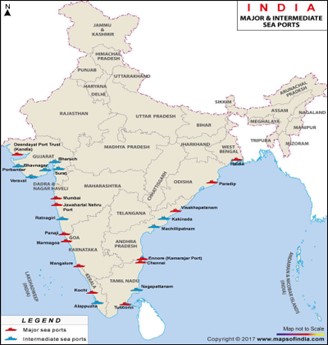
Which of the following is the correct order of sea ports of India from North to South?
Correct
Solution (c)
 Incorrect
Solution (c)
-
Question 3 of 35
3. Question
With reference to the Continental Slope, consider the following statements
- It connects the continental shelf and the ocean basins.
- It is the gently sloping seaward extension of continental plate.
- Its boundary indicates the end of the continents and various reliefs like canyons and trenches are present here.
How many of the above statements are correct?
Correct
Solution (b)
Statement 1 Statement 2 Statement 3 Correct Incorrect Correct The Continental Slope connects the continental shelf and the ocean basins. It begins where the bottom of the continental shelf sharply drops off into a steep slope. The gradient of the slope region varies between 2-5°. Its depth varies between 200 and 3,000 m.
The Continental Shelf is the gently sloping seaward extension of continental plate. These extended margins of each continent are occupied by relatively shallow seas and gulfs. Continental Shelf is not gentle slope rather a sharp slope.
The Continental Slope boundary indicates the end of the continents and various reliefs like canyons and trenches are present here. Incorrect
Solution (b)
Statement 1 Statement 2 Statement 3 Correct Incorrect Correct The Continental Slope connects the continental shelf and the ocean basins. It begins where the bottom of the continental shelf sharply drops off into a steep slope. The gradient of the slope region varies between 2-5°. Its depth varies between 200 and 3,000 m.
The Continental Shelf is the gently sloping seaward extension of continental plate. These extended margins of each continent are occupied by relatively shallow seas and gulfs. Continental Shelf is not gentle slope rather a sharp slope.
The Continental Slope boundary indicates the end of the continents and various reliefs like canyons and trenches are present here. -
Question 4 of 35
4. Question
Consider the following statements
- Tsunamis are a series of waves which are generated by the movement of the sea floor only due to earthquakes.
- The Indian National Centre for Ocean Information System (INCOIS) through Indian Tsunami Early Warning Centre (ITEWC) is the nodal agency to provide tsunami advisories to India.
Choose the correct code:
Correct
Solution (b)
Statement 1 Statement 2 Incorrect Correct Tsunamis are a series of waves which are generated by the movement of the sea floor due to various geophysical phenomena such as earthquakes, landslides and volcanic eruptions. The Indian National Centre for Ocean Information System INCOIS through Indian Tsunami Early Warning Centre (ITEWC) is the nodal agency to provide tsunami advisories to India. The INCOIS was established in 1999 as an autonomous body under the Ministry of Earth Sciences. It is coordinating with the Disaster Management Officials (DMOs) for implementation of Tsunami Ready
programme in India and conducts IOWave Tsunami mock exercises biannually to strengthen the readiness to handle the emergency situations with stakeholders.
Incorrect
Solution (b)
Statement 1 Statement 2 Incorrect Correct Tsunamis are a series of waves which are generated by the movement of the sea floor due to various geophysical phenomena such as earthquakes, landslides and volcanic eruptions. The Indian National Centre for Ocean Information System INCOIS through Indian Tsunami Early Warning Centre (ITEWC) is the nodal agency to provide tsunami advisories to India. The INCOIS was established in 1999 as an autonomous body under the Ministry of Earth Sciences. It is coordinating with the Disaster Management Officials (DMOs) for implementation of Tsunami Ready
programme in India and conducts IOWave Tsunami mock exercises biannually to strengthen the readiness to handle the emergency situations with stakeholders.
-
Question 5 of 35
5. Question
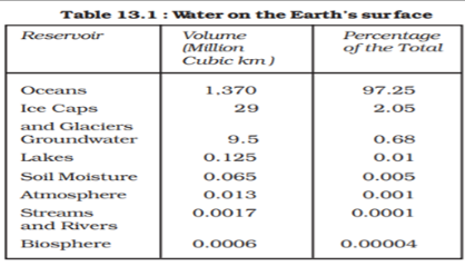
Consider the following statements regarding the distribution of water on the Earth’s surface
- The highest percentage of water is found in Ice Caps.
- The percentage of water in groundwater is more than lakes.
- The percentage of water in soil moisture is more than streams and rivers.
How many of the above statements are correct?
Correct
Solution (b)
The distribution of water on the Earth’s surface is extremely uneven. Only 3% of water on the surface is fresh; the remaining 97% resides in the ocean. Of freshwater, 69% resides in glaciers, 30% underground, and less than 1% is located in lakes, rivers, and swamps. The below chart gives the exact details about it.
 Incorrect
Solution (b)
The distribution of water on the Earth’s surface is extremely uneven. Only 3% of water on the surface is fresh; the remaining 97% resides in the ocean. Of freshwater, 69% resides in glaciers, 30% underground, and less than 1% is located in lakes, rivers, and swamps. The below chart gives the exact details about it.
-
Question 6 of 35
6. Question
Consider the following statements about Ocean Mean Temperature (OMT)
- It is more stable and consistent when compared to Sea Mean Temperature.
- It is measured up to a depth of 26⁰C isotherm which is at depth of 300 meters.
Which of the statements given above is/are correct?
Correct
Solution (a)
Statement 1 Statement 2 Correct Incorrect Ocean Mean Temperature (OMT) is more stable and consistent when compared to Sea Surface Temperature (SST) because SST is restricted to few millimetres of top ocean layer which is largely influenced by strong winds and evaporation.
OMT is measured up to a depth of 26⁰C isotherm which is at depth of 50-100 meters. OMT is analysed by measuring ocean thermal energy during the January – March period and it also predicts Indian summer monsoon.
Incorrect
Solution (a)
Statement 1 Statement 2 Correct Incorrect Ocean Mean Temperature (OMT) is more stable and consistent when compared to Sea Surface Temperature (SST) because SST is restricted to few millimetres of top ocean layer which is largely influenced by strong winds and evaporation.
OMT is measured up to a depth of 26⁰C isotherm which is at depth of 50-100 meters. OMT is analysed by measuring ocean thermal energy during the January – March period and it also predicts Indian summer monsoon.
-
Question 7 of 35
7. Question
Consider the following statements regarding South China Sea
- It is connected to the East China Sea through the Taiwan Strait.
- The nine-dash line lies in the South China Sea.
- It lies between China, Taiwan, the Philippines, Brunei, Malaysia, Indonesia and Vietnam.
Which of the statements given above is/are correct?
Correct
Solution (d)
Statement 1 Statement 2 Statement 3 Correct Correct Correct South China Sea is connected to the East China Sea through the Taiwan Strait. The nine-dash line lies in the South China Sea. It lies between China, Taiwan, the Philippines, Brunei, Malaysia, Indonesia and Vietnam. It is bounded in the North by the shores of South China, in the West by the Indochinese Peninsula, in the East by the Islands of Taiwan and the North-Western Philippines, and in the South by Borneo, Eastern Sumatra, and the Bangka Belitung Islands.
Incorrect
Solution (d)
Statement 1 Statement 2 Statement 3 Correct Correct Correct South China Sea is connected to the East China Sea through the Taiwan Strait. The nine-dash line lies in the South China Sea. It lies between China, Taiwan, the Philippines, Brunei, Malaysia, Indonesia and Vietnam. It is bounded in the North by the shores of South China, in the West by the Indochinese Peninsula, in the East by the Islands of Taiwan and the North-Western Philippines, and in the South by Borneo, Eastern Sumatra, and the Bangka Belitung Islands.
-
Question 8 of 35
8. Question
Consider the following statements
- Spring tides are formed when the sun, the moon and the earth are in a straight line.
- Neap tides are formed when the sun and moon are at right angles to each other.
Which of the statements given above is/are correct?
Correct
Solution (c)
Statement 1 Statement 2 Correct Correct Spring tides are formed when the sun, the moon and the earth are in a straight line. They occur twice a month, one on full moon period and another during new moon period.
Neap tides are formed when the sun and moon are at right angles to each other. It also occurs twice and there is a seven day interval between the spring tides and neap tides.
Incorrect
Solution (c)
Statement 1 Statement 2 Correct Correct Spring tides are formed when the sun, the moon and the earth are in a straight line. They occur twice a month, one on full moon period and another during new moon period.
Neap tides are formed when the sun and moon are at right angles to each other. It also occurs twice and there is a seven day interval between the spring tides and neap tides.
-
Question 9 of 35
9. Question
Consider the following statements
- The Socotra Island is an island of Italy located in the Arctic Ocean.
- The Reunion Island is the overseas island of French located in the Indian Ocean.
Choose the correct code:
Correct
Solution (b)
Statement 1 Statement 2 Incorrect Correct The Socotra Island is an island of Yemen located between the Arabian Sea and the Guardafui Channel. The Reunion island is the overseas island of French located in the Indian Ocean. Incorrect
Solution (b)
Statement 1 Statement 2 Incorrect Correct The Socotra Island is an island of Yemen located between the Arabian Sea and the Guardafui Channel. The Reunion island is the overseas island of French located in the Indian Ocean. -
Question 10 of 35
10. Question
Consider the following ocean currents
- Humboldt
- Gulf Stream
- Labrador
- Oyashio
Which of the above are Cold Ocean currents?
Correct
Solution (b)
All the currents given in the question except the Gulf stream are cold currents
Ocean currents are streams of water flowing constantly on the ocean surface in definite directions.
The ocean currents may be warm or cold
Generally, warm ocean currents originate near the equator and move towards the poles. The cold currents carry water from polar or higher latitudes to tropical or lower altitudes.
The Labrador Ocean current, Humboldt(peruvian) and oyoshio current is cold while the Gulf Stream is a warm current. The ocean current influence the temperature conditions of the area. Warm currents bring about warm temperatures over the land surface.
Incorrect
Solution (b)
All the currents given in the question except the Gulf stream are cold currents
Ocean currents are streams of water flowing constantly on the ocean surface in definite directions.
The ocean currents may be warm or cold
Generally, warm ocean currents originate near the equator and move towards the poles. The cold currents carry water from polar or higher latitudes to tropical or lower altitudes.
The Labrador Ocean current, Humboldt(peruvian) and oyoshio current is cold while the Gulf Stream is a warm current. The ocean current influence the temperature conditions of the area. Warm currents bring about warm temperatures over the land surface.
-
Question 11 of 35
11. Question
Consider the following statements with respect to Tides
- Tides are the rhythmic rise and fall of ocean water which generally happens twice in a day
- The strong gravitational pull exerted by the Sun and the Moon on the Earth’s surface causes the tides.
- During the full Moon and new Moon days, the Earth experiences Neap tides.
How many of the above statements are correct?
Correct
Solution (b)
Statement 1 Statement 2 Statement 3 Correct Correct Incorrect The rhythmic rise and fall of ocean water twice a day is called a tide. It is high tide when water covers much of the shore by rising to its highest level. It is low tide when water falls to its lowest level and recedes from the shore. Thus it happens twice a day generally. The strong gravitational pull exerted by the Sun and the Moon on the Earth’s surface causes the tides. The water of the Earth closer to the Moon gets pulled under the influence of the Moon’s gravitational force and causes high tides. During the full Moon and new Moon days, the Sun, the Moon and the Earth are in the same line and the tides are highest. These tides are called spring tides. ( Not Neap tides) NEAP TIDES
When the Moon is in its first and last quarter the ocean water gets drawn in diagonally opposite directions by the gravitational pull of the Sun and Moon resulting in low tides. These tides are Neap tides
Incorrect
Solution (b)
Statement 1 Statement 2 Statement 3 Correct Correct Incorrect The rhythmic rise and fall of ocean water twice a day is called a tide. It is high tide when water covers much of the shore by rising to its highest level. It is low tide when water falls to its lowest level and recedes from the shore. Thus it happens twice a day generally. The strong gravitational pull exerted by the Sun and the Moon on the Earth’s surface causes the tides. The water of the Earth closer to the Moon gets pulled under the influence of the Moon’s gravitational force and causes high tides. During the full Moon and new Moon days, the Sun, the Moon and the Earth are in the same line and the tides are highest. These tides are called spring tides. ( Not Neap tides) NEAP TIDES
When the Moon is in its first and last quarter the ocean water gets drawn in diagonally opposite directions by the gravitational pull of the Sun and Moon resulting in low tides. These tides are Neap tides
-
Question 12 of 35
12. Question
Consider the following statements with respect to Tidal energy
- Tidal energy can be best harnessed by building dams at narrow openings of the sea.
- During high tides the energy of the tides is used to turn the turbine installed in the dam to produce electricity
- The Gulf of Kachchh in India has a huge potential for harnessing Tidal energy
How many of the above statements are correct?
Correct
Solution (c)
Statement 1 Statement 2 Statement 3 Correct Correct Correct Energy generated from tides is called tidal energy. Tidal energy can be harnessed by building dams at narrow openings in the sea. During high tides, the energy of the tides is used to turn the turbine installed in the dam to produce electricity. Russia, France and the Gulf of Kachchh in India have huge tidal mill farms The Gulf of Kutch near Gujarat have an estimated potential of 7000 MW and 1200 MW, respectively and even the Gangetic delta in the Sundarbans of West Bengal has a potential of 100 MW Incorrect
Solution (c)
Statement 1 Statement 2 Statement 3 Correct Correct Correct Energy generated from tides is called tidal energy. Tidal energy can be harnessed by building dams at narrow openings in the sea. During high tides, the energy of the tides is used to turn the turbine installed in the dam to produce electricity. Russia, France and the Gulf of Kachchh in India have huge tidal mill farms The Gulf of Kutch near Gujarat have an estimated potential of 7000 MW and 1200 MW, respectively and even the Gangetic delta in the Sundarbans of West Bengal has a potential of 100 MW -
Question 13 of 35
13. Question
Which of the following is not a minor relief feature in the ocean?
Correct
Solution (b)
Statement 1 Statement 2 Statement 3 Statement 4 Incorrect Correct Incorrect Incorrect SEAMOUNT It is a mountain with pointed summits, rising from the sea floor that does not reach the surface of the ocean.
Seamounts are volcanic in origin. These can be 3,000-4,500m tall. The Emperor seamount, an extension of the Hawaiian Islands in the Pacific Ocean, is a good example.
TRENCHES These areas are the deepest parts of the oceans. The trenches are relatively steep-sided, narrow basins. They are some 3-5 km deeper than the surrounding ocean floor. They occur at the bases of continental slopes and along island arcs and are associated with active volcanoes.
This is a major relief feature in the ocean.
GUYOT Guyot is a flat-topped seamount. They show evidence of gradual subsidence through stages to become flat-topped submerged mountains.
It is estimated that more than 10,000 seamounts and guyots exist in the Pacific Ocean alone.
SUBMARINE CANYON These are deep valleys, some comparable to the Grand Canyon of the Colorado River. They are sometimes found cutting across the continental shelves and slopes, often extending from the mouths of large rivers.
The Hudson Canyon is the best-known canyon in the world.
Incorrect
Solution (b)
Statement 1 Statement 2 Statement 3 Statement 4 Incorrect Correct Incorrect Incorrect SEAMOUNT It is a mountain with pointed summits, rising from the sea floor that does not reach the surface of the ocean.
Seamounts are volcanic in origin. These can be 3,000-4,500m tall. The Emperor seamount, an extension of the Hawaiian Islands in the Pacific Ocean, is a good example.
TRENCHES These areas are the deepest parts of the oceans. The trenches are relatively steep-sided, narrow basins. They are some 3-5 km deeper than the surrounding ocean floor. They occur at the bases of continental slopes and along island arcs and are associated with active volcanoes.
This is a major relief feature in the ocean.
GUYOT Guyot is a flat-topped seamount. They show evidence of gradual subsidence through stages to become flat-topped submerged mountains.
It is estimated that more than 10,000 seamounts and guyots exist in the Pacific Ocean alone.
SUBMARINE CANYON These are deep valleys, some comparable to the Grand Canyon of the Colorado River. They are sometimes found cutting across the continental shelves and slopes, often extending from the mouths of large rivers.
The Hudson Canyon is the best-known canyon in the world.
-
Question 14 of 35
14. Question
Consider the following
Ocean Currents Types 1. Peruvian Current Cold Current 2. Brazil Current Warm Current 3. Norwegian Current Cold Current 4. Benguela Current Warm Current How many pairs are correctly matched?
Correct
Solution (b)
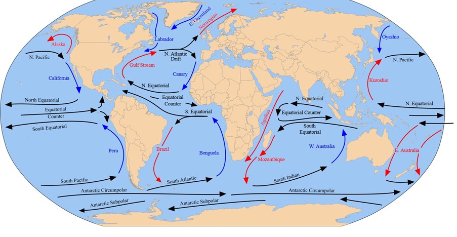
Blue arrow – cold current Red arrow – warm current
Incorrect
Solution (b)
Blue arrow – cold current Red arrow – warm current
-
Question 15 of 35
15. Question
Which of the following factors affects the ocean salinity?
- Evaporation
- Precipitation
- Winds
- Ocean currents
Select the correct answer using the code given below:
Correct
Solution (d)
Statement 1 Statement 2 Statement 3 Statement 4 Correct Correct Correct Correct Evaporation of ocean water and formation of sea ice both increase the salinity of the ocean. However these “salinity raising” factors are continually counterbalanced by processes that decrease salinity such as the continuous input of fresh water from rivers, precipitation of rain and snow, and melting of ice. Where more rain or snow falls over the ocean, it dilutes the salts in the seawater there. As a result, the water becomes fresher with time. If seawater becomes saltier, it may mean that rates of evaporation have increased or that precipitation has decreased over time. Winds also help in the redistribution of salts in the oceans and seas as winds drive away saline water to fewer saline areas resulting in a decrease of salinity in the former and increases in the latter. In other words, in the areas of upwelling of waterless saline water moves up from below whereas, in the areas where the water is piled up, salinity is increased. For example, trade winds drive away saline waters from the western coast of the continents and pile up salinity increases. Ocean currents affect the spatial distribution of salinity by mixing seawater. Equatorial warm currents drive away salts from the western coastal areas of the continent and accumulate them along with the eastern coastal areas. This adds to the high salinity of the Mexican Gulf. The North Atlantic drift, the extension of the gulf stream increases salinity along the north-western coasts of Europe. Similarly, salinity is reduced along the north-eastern coast. America due to cold labrador current. Ocean currents have the least impact on salinity in enclosed waters, but currents have a significant impact on salinity in marginal seas with open sea contact through wide openings. For example, the North Atlantic drift raises the salinity of the Norwegian and the North Seas. Incorrect
Solution (d)
Statement 1 Statement 2 Statement 3 Statement 4 Correct Correct Correct Correct Evaporation of ocean water and formation of sea ice both increase the salinity of the ocean. However these “salinity raising” factors are continually counterbalanced by processes that decrease salinity such as the continuous input of fresh water from rivers, precipitation of rain and snow, and melting of ice. Where more rain or snow falls over the ocean, it dilutes the salts in the seawater there. As a result, the water becomes fresher with time. If seawater becomes saltier, it may mean that rates of evaporation have increased or that precipitation has decreased over time. Winds also help in the redistribution of salts in the oceans and seas as winds drive away saline water to fewer saline areas resulting in a decrease of salinity in the former and increases in the latter. In other words, in the areas of upwelling of waterless saline water moves up from below whereas, in the areas where the water is piled up, salinity is increased. For example, trade winds drive away saline waters from the western coast of the continents and pile up salinity increases. Ocean currents affect the spatial distribution of salinity by mixing seawater. Equatorial warm currents drive away salts from the western coastal areas of the continent and accumulate them along with the eastern coastal areas. This adds to the high salinity of the Mexican Gulf. The North Atlantic drift, the extension of the gulf stream increases salinity along the north-western coasts of Europe. Similarly, salinity is reduced along the north-eastern coast. America due to cold labrador current. Ocean currents have the least impact on salinity in enclosed waters, but currents have a significant impact on salinity in marginal seas with open sea contact through wide openings. For example, the North Atlantic drift raises the salinity of the Norwegian and the North Seas. -
Question 16 of 35
16. Question
Consider the following terminologies associated with the water footprint
- Blue water footprint: It is the volume of freshwater that evaporated from rainwater store in the soil as soil moisture to produce the goods and services.
- Green water footprint: It is the volume of water evaporated from the groundwater during production of products.
- Grey water footprint: It is the volume of polluted water that associates with the production of all goods and services for the individual or community.
How many of the above pairs are correctly matched?
Correct
Solution (a)
Statement 1 Statement 2 Statement 3 Incorrect Incorrect Correct Bluewater footprint: The blue water footprint is the volume of freshwater that evaporated from the global blue water resources (surface water and ground water) to produce the goods and services consumed by the individual or community.
Green water footprint: The green water footprint is the volume of water evaporated from the global green water resources (rainwater stored in the soil as soil moisture) during production or those incorporated in products.
Grey water footprint: The grey water footprint is the volume of polluted water that associates with the production of all goods and services for the individual or community. The latter can be estimated as the volume of water that is required to dilute pollutants to such an extent that the quality of the water remains at or above agreed water quality standards.
Incorrect
Solution (a)
Statement 1 Statement 2 Statement 3 Incorrect Incorrect Correct Bluewater footprint: The blue water footprint is the volume of freshwater that evaporated from the global blue water resources (surface water and ground water) to produce the goods and services consumed by the individual or community.
Green water footprint: The green water footprint is the volume of water evaporated from the global green water resources (rainwater stored in the soil as soil moisture) during production or those incorporated in products.
Grey water footprint: The grey water footprint is the volume of polluted water that associates with the production of all goods and services for the individual or community. The latter can be estimated as the volume of water that is required to dilute pollutants to such an extent that the quality of the water remains at or above agreed water quality standards.
-
Question 17 of 35
17. Question
With reference to ocean currents consider the following statements:
- The best fishing grounds of the world exist in the regions where warm and cold currents meet.
- Ocean currents assist in maintaining the Earth’s heat balance.
Which of the statements given above is/are correct?
Correct
Solution (c)
Statement 1 Statement 2 Correct Correct The mixing of warm and cold currents helps to replenish the oxygen and favour the growth of plankton, the primary food for the fish population. The best fishing grounds in the world exist mainly in these mixing zones. Example Newfoundland in USA and off the coastlands of Japan
Ocean currents have several direct and indirect influences on human activities. The West coasts of the continents in tropical and subtropical latitudes (except close to the equator) are bordered by cool waters. Their average temperatures are relatively low with narrow diurnal and annual ranges. There is fog, but generally, the areas are arid. West coasts of the continents in the middle and higher latitudes are bordered by warm waters which cause a distinct marine climate. They are characterized by cool summers and relatively mild winters with a narrow annual range of temperatures. Warm currents flow parallel to the east coasts of the continents in tropical and subtropical latitudes. This results in warm and rainy climates. These areas lie in the western margins of the subtropical anti-cyclones.
Incorrect
Solution (c)
Statement 1 Statement 2 Correct Correct The mixing of warm and cold currents helps to replenish the oxygen and favour the growth of plankton, the primary food for the fish population. The best fishing grounds in the world exist mainly in these mixing zones. Example Newfoundland in USA and off the coastlands of Japan
Ocean currents have several direct and indirect influences on human activities. The West coasts of the continents in tropical and subtropical latitudes (except close to the equator) are bordered by cool waters. Their average temperatures are relatively low with narrow diurnal and annual ranges. There is fog, but generally, the areas are arid. West coasts of the continents in the middle and higher latitudes are bordered by warm waters which cause a distinct marine climate. They are characterized by cool summers and relatively mild winters with a narrow annual range of temperatures. Warm currents flow parallel to the east coasts of the continents in tropical and subtropical latitudes. This results in warm and rainy climates. These areas lie in the western margins of the subtropical anti-cyclones.
-
Question 18 of 35
18. Question
With reference to vertical distribution of salinity of oceans, consider the following statements
- Salinity at surfaces is very much fixed
- Salinity at depths increases by the loss of water or evaporation
- In a distinct zone called the halocline the salinity increases sharply.
How many of the above statements are correct?
Correct
Solution (a)
Statement 1 Statement 2 Statement 3 Incorrect Incorrect Correct Salinity at the surface increases by the loss of water to ice or evaporation or decreased by the input of fresh waters, such as from the rivers. Salinity at depth is very much fixed because there is no way that water is ‘lost’, or the salt is ‘added.’ There is a marked difference in the salinity between the surface zones and the deep zones of the oceans. The lower salinity water rests above the higher salinity dense water. Salinity, generally, increases with depth and there is a distinct zone called the halocline, where salinity increases sharply. Other factors being constant, increasing the salinity of seawater causes its density to increase. High-salinity seawater, generally, sinks below the lower-salinity water. This leads to stratification by salinity.
Incorrect
Solution (a)
Statement 1 Statement 2 Statement 3 Incorrect Incorrect Correct Salinity at the surface increases by the loss of water to ice or evaporation or decreased by the input of fresh waters, such as from the rivers. Salinity at depth is very much fixed because there is no way that water is ‘lost’, or the salt is ‘added.’ There is a marked difference in the salinity between the surface zones and the deep zones of the oceans. The lower salinity water rests above the higher salinity dense water. Salinity, generally, increases with depth and there is a distinct zone called the halocline, where salinity increases sharply. Other factors being constant, increasing the salinity of seawater causes its density to increase. High-salinity seawater, generally, sinks below the lower-salinity water. This leads to stratification by salinity.
-
Question 19 of 35
19. Question
With reference to La Nina, consider the following statements:
- La Nina is a natural ocean-atmospheric phenomenon marked by cooler-than-average sea surface temperatures across the central and eastern Pacific Ocean.
- La Nina is one part of the El Nino Southern Oscillation (ENSO) cycle, which is characterized by opposing warm and cool phases of oceanic and atmospheric conditions in the tropical Pacific Ocean.
- The strongest La Niñas tend to be stronger than the strongest El Ninos.
How many of the statements given above is/are correct?
Correct
Solution (b)
Statement 1 Statement 2 Statement 3 Correct Correct Incorrect La Nina is a natural ocean-atmospheric phenomenon marked by cooler-than average sea surface temperatures across the central and eastern Pacific Ocean near the equator and is translated from Spanish as “little girl.” La Nina is one part of the El Nino Southern Oscillation (ENSO) cycle, which is characterized by opposing warm and cool phases of oceanic and atmospheric conditions in the tropical Pacific Ocean. Consecutive La Ninas following a transition through ENSO neutral conditions are not uncommon and can be referred to as a “double-dip.” We see some subtle but important differences between El Niño and La Niña in terms of their patterns and behavior. First, the sea surface temperature anomalies (difference from the long-term average) during El Niño tend to be centered farther east than for La Niña, especially for the stronger El Niño episodes. Second, the strongest El Niños tend to be stronger than the strongest La Niñas.
Incorrect
Solution (b)
Statement 1 Statement 2 Statement 3 Correct Correct Incorrect La Nina is a natural ocean-atmospheric phenomenon marked by cooler-than average sea surface temperatures across the central and eastern Pacific Ocean near the equator and is translated from Spanish as “little girl.” La Nina is one part of the El Nino Southern Oscillation (ENSO) cycle, which is characterized by opposing warm and cool phases of oceanic and atmospheric conditions in the tropical Pacific Ocean. Consecutive La Ninas following a transition through ENSO neutral conditions are not uncommon and can be referred to as a “double-dip.” We see some subtle but important differences between El Niño and La Niña in terms of their patterns and behavior. First, the sea surface temperature anomalies (difference from the long-term average) during El Niño tend to be centered farther east than for La Niña, especially for the stronger El Niño episodes. Second, the strongest El Niños tend to be stronger than the strongest La Niñas.
-
Question 20 of 35
20. Question
Consider the following statements about landforms formed by wave action.
- Bars are deposits of sand and gravel laid down by waves and currents which separate the shoreline from the sea.
- Tombolo is a deposition landform in which an island is attached to the mainland by a narrow piece of land such as a spit or bar.
Which of the statements given above is/are correct?
Correct
Solution (c)
Statement 1 Statement 2 Correct Correct Bars are deposits of sand and gravel laid down by waves and currents which separate the shoreline from the sea. They are submerged or partly exposed ridge of sand or coarse sediment that is built by waves offshore from a beach. Tombolo is a deposition landform in which an island is attached to the mainland by a narrow piece of land such as a spit or bar. A tombolo is a sediment deposit at the coast formed by wave refraction and diffraction at the edges of an obstacle (natural or artificial) originally detached from the mainland. 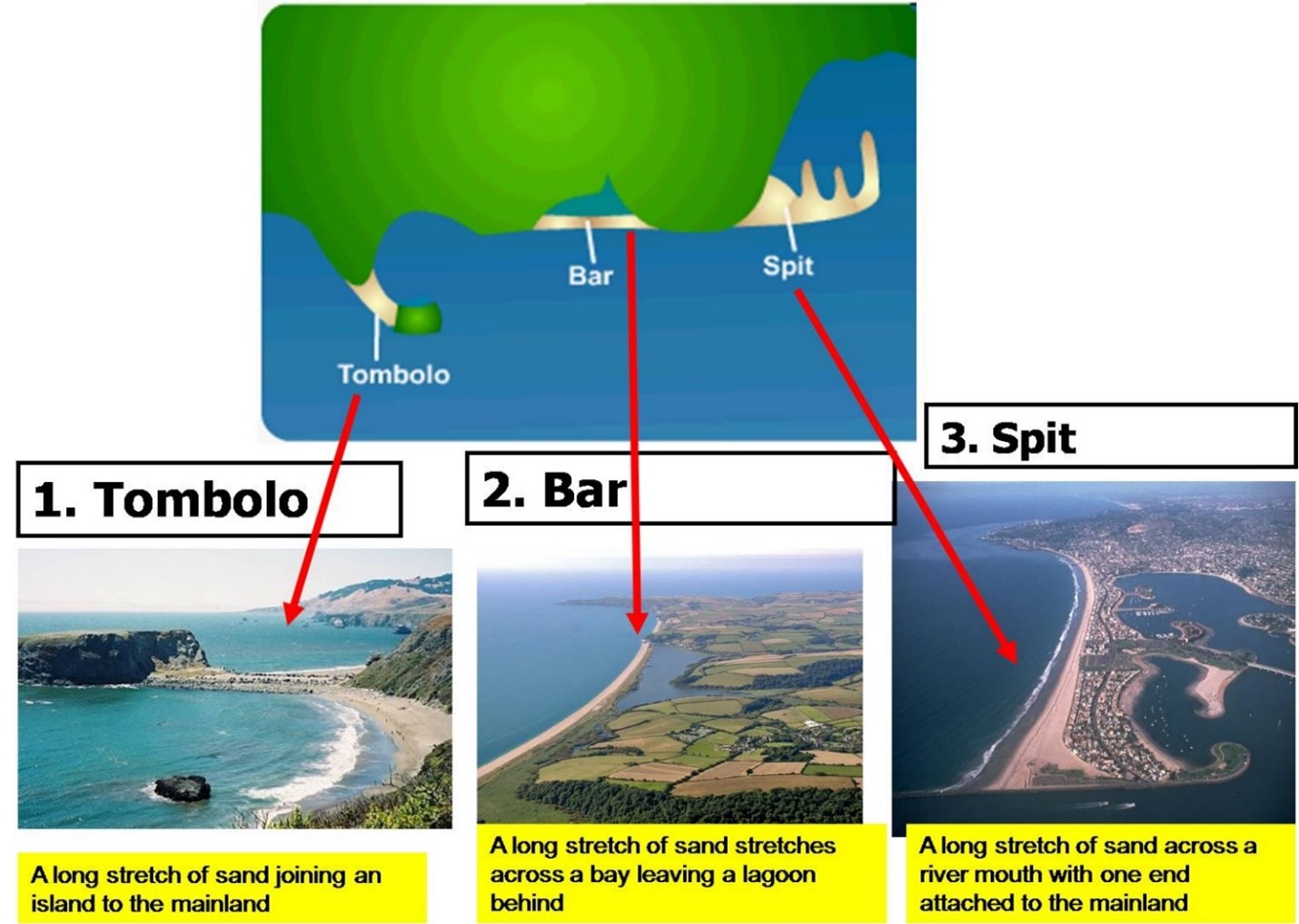 Incorrect
Solution (c)
Statement 1 Statement 2 Correct Correct Bars are deposits of sand and gravel laid down by waves and currents which separate the shoreline from the sea. They are submerged or partly exposed ridge of sand or coarse sediment that is built by waves offshore from a beach. Tombolo is a deposition landform in which an island is attached to the mainland by a narrow piece of land such as a spit or bar. A tombolo is a sediment deposit at the coast formed by wave refraction and diffraction at the edges of an obstacle (natural or artificial) originally detached from the mainland. -
Question 21 of 35
21. Question
Consider the following statements regarding the powers of the Central Consumer Protection Authority (CCPA):
- It has the authority to ban the endorser of a false or misleading advertisement from endorsing any product or service.
- It can issue safety notices to alert consumers about dangerous, hazardous, or unsafe goods, or services.
- It has the power to issue directions and guidelines aimed at preventing unfair trade practices and protecting consumers’ interests.
How many of the above statements are correct?
Correct
Solution (c)
Central Consumer Protection Authority (CCPA) is a regulatory body that was established under the Consumer Protection Act 2019. It aims to protect the rights of consumers by cracking down on unfair trade practices, false and misleading advertisements, and e-commerce issues that are detrimental to the interests of the public and consumers. The powers of the Central Consumer Protection Authority (CCPA) are:
- It has the authority to ban the endorser of a false or misleading advertisement from endorsing any product or service. The duration of the prohibition can vary, with a longer period for subsequent contraventions. However, there’s a provision that exempts endorsers from liability if they have exercised due diligence to verify the claims made in the advertisement. Hence statement 1 is correct.
- It has the authority to inquire into or investigate matters related to violations of consumer rights or unfair trade practices, on its initiative, upon receiving a complaint, or upon direction from the central government.
- It can issue safety notices to alert consumers about dangerous, hazardous, or unsafe goods, or services. Hence statement 2 is correct.
- It can file complaints before the relevant Consumer Disputes Redressal Commission seeking orders or directions. This includes actions such as recalling unsafe goods and services, reimbursement of the price paid, and discontinuation of unfair trade practices and misleading advertisements.
- It has the power to issue directions and guidelines aimed at preventing unfair trade practices and protecting consumers’ interests. Hence statement 3 is correct.
Incorrect
Solution (c)
Central Consumer Protection Authority (CCPA) is a regulatory body that was established under the Consumer Protection Act 2019. It aims to protect the rights of consumers by cracking down on unfair trade practices, false and misleading advertisements, and e-commerce issues that are detrimental to the interests of the public and consumers. The powers of the Central Consumer Protection Authority (CCPA) are:
- It has the authority to ban the endorser of a false or misleading advertisement from endorsing any product or service. The duration of the prohibition can vary, with a longer period for subsequent contraventions. However, there’s a provision that exempts endorsers from liability if they have exercised due diligence to verify the claims made in the advertisement. Hence statement 1 is correct.
- It has the authority to inquire into or investigate matters related to violations of consumer rights or unfair trade practices, on its initiative, upon receiving a complaint, or upon direction from the central government.
- It can issue safety notices to alert consumers about dangerous, hazardous, or unsafe goods, or services. Hence statement 2 is correct.
- It can file complaints before the relevant Consumer Disputes Redressal Commission seeking orders or directions. This includes actions such as recalling unsafe goods and services, reimbursement of the price paid, and discontinuation of unfair trade practices and misleading advertisements.
- It has the power to issue directions and guidelines aimed at preventing unfair trade practices and protecting consumers’ interests. Hence statement 3 is correct.
-
Question 22 of 35
22. Question
The term “two-state solution” is mentioned in news in the context of which of the following country?
Correct
Solution (d)
The two-state solution is used in the context of the Israel–Palestine issue. The two-state solution would create an independent Israel and Palestine and is the mainstream approach to resolving the conflict. The 1993 Oslo Accords marked the first time that the State of Israel and the Palestine Liberation Organization (PLO) formally recognized one another and publicly committed to negotiate a solution to their decades-long conflict. Its vision requires Israel to abandon its opposition to Palestinian claims (to national sovereignty). Hence option d is correct.
Incorrect
Solution (d)
The two-state solution is used in the context of the Israel–Palestine issue. The two-state solution would create an independent Israel and Palestine and is the mainstream approach to resolving the conflict. The 1993 Oslo Accords marked the first time that the State of Israel and the Palestine Liberation Organization (PLO) formally recognized one another and publicly committed to negotiate a solution to their decades-long conflict. Its vision requires Israel to abandon its opposition to Palestinian claims (to national sovereignty). Hence option d is correct.
-
Question 23 of 35
23. Question
Consider the following statements about Golan Heights:
- It is a region located in south-western Syria.
- Israel captured it during the Six-Day War in 1967.
Which of the statements given above is/are correct?
Correct
Solution (c)
- Golan Heights is a region located in southwestern Syria. Hence statement 1 is correct.
- Southern Syria is visible from the top of the Golan Heights. This gives Israel an advantage in monitoring Syrian movements.
- Rainwater from the Golan’s catchment feeds into the Jordan River.
- Israel captured it during the Six-Day War in 1967 and annexed it in 1981. Hence statement 2 is correct.
- This move was not recognised internationally, but the US did so unilaterally in 2019.
Incorrect
Solution (c)
- Golan Heights is a region located in southwestern Syria. Hence statement 1 is correct.
- Southern Syria is visible from the top of the Golan Heights. This gives Israel an advantage in monitoring Syrian movements.
- Rainwater from the Golan’s catchment feeds into the Jordan River.
- Israel captured it during the Six-Day War in 1967 and annexed it in 1981. Hence statement 2 is correct.
- This move was not recognised internationally, but the US did so unilaterally in 2019.
-
Question 24 of 35
24. Question
Consider the following statements:
- The Fifth Schedule of the Constitution provides for the formation of autonomous administrative divisions called Autonomous District Councils (ADCs).
- Autonomous District Councils (ADCs) have up to 30 members with a term of five years.
- Autonomous District Councils (ADCs) are empowered to make legislative laws on matters like land, forests, fisheries, and social security with due approval from the governor.
How many of the above statements are correct?
Correct
Solution (b)
- The Sixth Schedule of the Constitution provides for the formation of autonomous administrative divisions called Autonomous District Councils (ADCs). Hence statement 1 is incorrect.
- The sixth schedule applies to Assam, Meghalaya, Tripura, and Mizoram.
- Autonomous District Councils (ADCs) have up to 30 members with a term of five years. Hence statement 2 is correct.
- ADCs can constitute village courts within their jurisdiction to hear trials of cases involving the tribes. Governors specify the jurisdiction of high courts for each of these cases.
- Autonomous District Councils (ADCs) are empowered to make legislative laws on matters like land, forests, fisheries, and social security with due approval from the governor. Hence statement 3 is correct.
- The acts of Parliament or the state legislaturedo not apply to autonomous districts and autonomous regions or apply with specified modifications and exceptions.
Incorrect
Solution (b)
- The Sixth Schedule of the Constitution provides for the formation of autonomous administrative divisions called Autonomous District Councils (ADCs). Hence statement 1 is incorrect.
- The sixth schedule applies to Assam, Meghalaya, Tripura, and Mizoram.
- Autonomous District Councils (ADCs) have up to 30 members with a term of five years. Hence statement 2 is correct.
- ADCs can constitute village courts within their jurisdiction to hear trials of cases involving the tribes. Governors specify the jurisdiction of high courts for each of these cases.
- Autonomous District Councils (ADCs) are empowered to make legislative laws on matters like land, forests, fisheries, and social security with due approval from the governor. Hence statement 3 is correct.
- The acts of Parliament or the state legislaturedo not apply to autonomous districts and autonomous regions or apply with specified modifications and exceptions.
-
Question 25 of 35
25. Question
With reference to the Bletchley Declaration, consider the following statements:
- The central objective of the Declaration is to address risks and responsibilities associated with frontier AI in a comprehensive and collaborative manner.
- The Declaration establishes a global AI ethics board to oversee all AI development.
- The Declaration was adopted by all the members of the United Nations General Assembly (UNGA).
How many of the above statements are correct?
Correct
Solution (a)
- The central objective of the Bletchley Declaration is to address risks and responsibilities associated with frontier AI in a comprehensive and collaborative manner. It emphasizes the necessity of aligning AI systems with human intent and urges a deeper exploration of AI’s full capabilities. Hence statement 1 is correct.
- The Bletchley Declaration does not establish a global AI ethics board to oversee all AI development. Instead, it sets forth a shared understanding of the opportunities and risks posed by AI and the need for governments to work together to meet the most significant challenges posed by the technology. Hence statement 2 is incorrect.
- The Bletchley Declaration is a recent initiative by the UK government to promote international cooperation in ensuring the safe use of artificial intelligence (AI) systems. It was signed by 27 countries, including India, China, the United States, and the United Kingdom, as well as the European Union. However, it is not an official document of the United Nations or any other international organization. It’s not something that was voted on by the UNGA or any other body. Hence statement 3 is incorrect.
Incorrect
Solution (a)
- The central objective of the Bletchley Declaration is to address risks and responsibilities associated with frontier AI in a comprehensive and collaborative manner. It emphasizes the necessity of aligning AI systems with human intent and urges a deeper exploration of AI’s full capabilities. Hence statement 1 is correct.
- The Bletchley Declaration does not establish a global AI ethics board to oversee all AI development. Instead, it sets forth a shared understanding of the opportunities and risks posed by AI and the need for governments to work together to meet the most significant challenges posed by the technology. Hence statement 2 is incorrect.
- The Bletchley Declaration is a recent initiative by the UK government to promote international cooperation in ensuring the safe use of artificial intelligence (AI) systems. It was signed by 27 countries, including India, China, the United States, and the United Kingdom, as well as the European Union. However, it is not an official document of the United Nations or any other international organization. It’s not something that was voted on by the UNGA or any other body. Hence statement 3 is incorrect.
-
Question 26 of 35
26. Question
Consider the following statements about the Loss and Damage (L&D) Fund:
- It is a fund created to provide financial assistance to nations most vulnerable and impacted by the effects of climate change.
- The World Bank will be the interim host of the fund for a period of four years.
- All countries can contribute to the fund voluntarily.
- All developed countries are eligible to apply for the fund.
Choose the correct code:
Correct
Solution (c)
- The Loss and Damage (L&D) Fund is a fund created to provide financial assistance to nations most vulnerable and impacted by the effects of climate change. Hence statement 1 is correct.
- The World Bank will be the interim host of the fund for a period of four years. Hence statement 2 is correct.
- All countries can contribute to the fund voluntarily. Hence statement 3 is correct.
- Countries have already committed at least $450 million to the fund.
- All developing countries are eligible to apply for the fund. Hence statement 4 is incorrect.
- A certain percentage of the fund has been set apart for least developed countries and small island developing states.
Incorrect
Solution (c)
- The Loss and Damage (L&D) Fund is a fund created to provide financial assistance to nations most vulnerable and impacted by the effects of climate change. Hence statement 1 is correct.
- The World Bank will be the interim host of the fund for a period of four years. Hence statement 2 is correct.
- All countries can contribute to the fund voluntarily. Hence statement 3 is correct.
- Countries have already committed at least $450 million to the fund.
- All developing countries are eligible to apply for the fund. Hence statement 4 is incorrect.
- A certain percentage of the fund has been set apart for least developed countries and small island developing states.
-
Question 27 of 35
27. Question
Consider the following statements about Vajrayana Buddhism:
- Its four main schools are Nyingma, Kagyu, Sakya, and Gelug.
- Its common deities include Tara, Avalokiteshvara, Manjushri, and
- It is regarded as the third turning of the wheel of Dharma.
How many of the above statements are correct?
Correct
Solution (c)
- Vajrayana Buddhism also known as Tantric Buddhism, is a form of Buddhism that developed in India and later spread to Tibet, Bhutan, Mongolia, and other regions.
- It claims that tantras, mantras, and yantras are superior vehicles to liberation since they contain numerous sophisticated tantric ritual practices.
- Its four main schools are Nyingma, Kagyu, Sakya, and Gelug. Hence statement 1 is correct.
- It views enlightenment as something that can be attained in a single lifetime.
- Its common deities include Tara, Avalokiteshvara, Manjushri, and Vajrapani. Hence statement 2 is correct.
- It draws upon elements of Mahayana Buddhism but also includes unique practices and teachings, such as tantra, deity yoga, meditative techniques, and esoteric rituals.
- It is regarded as the third turning of the wheel of Dharma. Hence statement 3 is correct.
- Tantric Buddhism uses art for teaching, healing, and meditation. In tantrism, art is seen as a powerful instrument for aiding spiritual development through rituals. Paintings of deities are used as a tool to evoke the subject or in some cases make contact directly.
Incorrect
Solution (c)
- Vajrayana Buddhism also known as Tantric Buddhism, is a form of Buddhism that developed in India and later spread to Tibet, Bhutan, Mongolia, and other regions.
- It claims that tantras, mantras, and yantras are superior vehicles to liberation since they contain numerous sophisticated tantric ritual practices.
- Its four main schools are Nyingma, Kagyu, Sakya, and Gelug. Hence statement 1 is correct.
- It views enlightenment as something that can be attained in a single lifetime.
- Its common deities include Tara, Avalokiteshvara, Manjushri, and Vajrapani. Hence statement 2 is correct.
- It draws upon elements of Mahayana Buddhism but also includes unique practices and teachings, such as tantra, deity yoga, meditative techniques, and esoteric rituals.
- It is regarded as the third turning of the wheel of Dharma. Hence statement 3 is correct.
- Tantric Buddhism uses art for teaching, healing, and meditation. In tantrism, art is seen as a powerful instrument for aiding spiritual development through rituals. Paintings of deities are used as a tool to evoke the subject or in some cases make contact directly.
-
Question 28 of 35
28. Question
Consider the following statements about Methotrexate (MTX):
- It is used to treat various medical conditions, primarily cancers, autoimmune diseases, and certain inflammatory conditions.
- A highly fluorescent material developed using phosphorene, cystine, and gold(Ph-Cys-Au) is used to detect MTX.
Choose the correct code:
Correct
Solution (c)
- Methotrexate (MTX) is used to treat various medical conditions, primarily cancers, autoimmune diseases, and certain inflammatory conditions. Hence statement 1 is correct.
- It belongs to a class of drugs known as antimetabolite.
- The MTX overdose in blood plasma is hazardous if it remains in the system for more than 10 hours, resulting in poisoning effects on the lungs, ulcers of the stomach, and heart stroke.
- A highly fluorescent material developed using phosphorene, cystine, and gold (Ph-Cys-Au) is used to detect MTX. Hence statement 2 is correct.
- It has exceptional optical properties and thus can be used as a visual sensing platform for detecting the anti-cancer drug MTX overdosage.
Incorrect
Solution (c)
- Methotrexate (MTX) is used to treat various medical conditions, primarily cancers, autoimmune diseases, and certain inflammatory conditions. Hence statement 1 is correct.
- It belongs to a class of drugs known as antimetabolite.
- The MTX overdose in blood plasma is hazardous if it remains in the system for more than 10 hours, resulting in poisoning effects on the lungs, ulcers of the stomach, and heart stroke.
- A highly fluorescent material developed using phosphorene, cystine, and gold (Ph-Cys-Au) is used to detect MTX. Hence statement 2 is correct.
- It has exceptional optical properties and thus can be used as a visual sensing platform for detecting the anti-cancer drug MTX overdosage.
-
Question 29 of 35
29. Question
Consider the following statements regarding the key findings of UNEP’s Emissions Gap Report 2023:
- The world is heading towards a 4°C temperature rise by 2100, compared to pre-industrial levels.
- This is the fourteenth Emissions Gap Report.
- To limit global warming to 2°C, emissions must be cut by 28% by 2030.
How many of the above statements are correct?
Correct
Solution (b)
The key findings of UNEP’s Emissions Gap Report 2023:
- The world is heading towards a 3°C temperature rise by 2100, compared to pre-industrial levels. Hence statement 1 is incorrect.
- Global emissions rose by 1.2% in 2022 from 2021, nearly returning to pre-pandemic levels.
- This fourteenth Emissions Gap Report is published ahead of the twenty-eighth session of the Conference of the Parties to the United Nations Framework on Climate Change (COP 28). Hence statement 2 is correct.
- The 2016 edition of the report had projected a warming of up to 3.4 degrees Celsius in a business-as-usual scenario. However, according to the Emissions Gap Report 2023, the current projection for the increase in emissions by 2030 is about 3%. Still, this is not enough to meet the 1.5°C target.
- To limit global warming to 2°C, emissions must be cut by 28% by 2030 and by 42% by 2030 for the 1.5°C target. Hence statement 3 is correct.
Incorrect
Solution (b)
The key findings of UNEP’s Emissions Gap Report 2023:
- The world is heading towards a 3°C temperature rise by 2100, compared to pre-industrial levels. Hence statement 1 is incorrect.
- Global emissions rose by 1.2% in 2022 from 2021, nearly returning to pre-pandemic levels.
- This fourteenth Emissions Gap Report is published ahead of the twenty-eighth session of the Conference of the Parties to the United Nations Framework on Climate Change (COP 28). Hence statement 2 is correct.
- The 2016 edition of the report had projected a warming of up to 3.4 degrees Celsius in a business-as-usual scenario. However, according to the Emissions Gap Report 2023, the current projection for the increase in emissions by 2030 is about 3%. Still, this is not enough to meet the 1.5°C target.
- To limit global warming to 2°C, emissions must be cut by 28% by 2030 and by 42% by 2030 for the 1.5°C target. Hence statement 3 is correct.
-
Question 30 of 35
30. Question
Consider the following statements about the Amplifi 2.0 Portal:
- It was launched by the Ministry of Housing and Urban Affairs.
- It aims to make raw data from Indian cities available on a single platform for academics, researchers, and stakeholders to help data-driven policymaking.
Choose the correct code:
Correct
Solution (c)
- The Amplifi 2.0 Portal was launched by the Ministry of Housing and Urban Affairs. Hence statement 1 is correct.
- Amplifi – Assessment and Monitoring Platform for Liveable, Inclusive, and Future-Ready Urban India portal.
- The portal provides data on various services for several cities such as:
- Total diesel consumption
- Number of water quality samples tested
- Average annual healthcare expenditure
- Total population residing in slums
- Recorded fatalities from road accidents
- It aims to make raw data from Indian cities available on a single platform for academics, researchers, and stakeholders to help data-driven policymaking. Hence statement 2 is correct.
- Currently, 258 urban local bodies have been onboarded and data for 150 cities is accessible on the platform.
- Eventually, data from the more than 4,000 Urban Local Bodies will be made available on the portal.
Note:
- According to the 2011 Census, 37.7 crore people (31% of the population) lived in urban areas. By 2030, this is projected to increase by 60 crores or 40%.
- In 2011, urban areas contributed 63% to the country’s GDP and this is projected to increase to 75% by 2030.
Incorrect
Solution (c)
- The Amplifi 2.0 Portal was launched by the Ministry of Housing and Urban Affairs. Hence statement 1 is correct.
- Amplifi – Assessment and Monitoring Platform for Liveable, Inclusive, and Future-Ready Urban India portal.
- The portal provides data on various services for several cities such as:
- Total diesel consumption
- Number of water quality samples tested
- Average annual healthcare expenditure
- Total population residing in slums
- Recorded fatalities from road accidents
- It aims to make raw data from Indian cities available on a single platform for academics, researchers, and stakeholders to help data-driven policymaking. Hence statement 2 is correct.
- Currently, 258 urban local bodies have been onboarded and data for 150 cities is accessible on the platform.
- Eventually, data from the more than 4,000 Urban Local Bodies will be made available on the portal.
Note:
- According to the 2011 Census, 37.7 crore people (31% of the population) lived in urban areas. By 2030, this is projected to increase by 60 crores or 40%.
- In 2011, urban areas contributed 63% to the country’s GDP and this is projected to increase to 75% by 2030.
-
Question 31 of 35
31. Question
A series is given, with one term missing. Choose the correct alternative from the given ones that will complete the series. 113, 127, 131, 137, 139,141, ?, 151, 157, 163, 167, 173.
Correct
Solution (c)
149 is the next possible prime number. The above series is series of prime numbers.
Incorrect
Solution (c)
149 is the next possible prime number. The above series is series of prime numbers.
-
Question 32 of 35
32. Question
A, B, C rent a pasture. A puts 10 oxen for 7 months, B puts 12 oxen for 5 months and C puts 15 oxen for 3 months for grazing. If the rent of the pasture is Rs. 175, how much must C pay as his share of rent?
Correct
Solution (a)
Ratio of shares of A, B, C
A : B : C = (10 x 7) : (12 x 5) : (15 x 3)
= 70 : 60 : 45
= 14 : 12 : 9.
C’s rent = Rs. 175 x (9/35) = Rs. 45
Incorrect
Solution (a)
Ratio of shares of A, B, C
A : B : C = (10 x 7) : (12 x 5) : (15 x 3)
= 70 : 60 : 45
= 14 : 12 : 9.
C’s rent = Rs. 175 x (9/35) = Rs. 45
-
Question 33 of 35
33. Question
O In a certain coded language, SUBLIME is coded as BEILMSU, NASTY is coded as ANSTY, then DIVINE is coded as
Correct
Solution (b)
All the alphabets in the word are written in alphabetical order within that word.
Incorrect
Solution (b)
All the alphabets in the word are written in alphabetical order within that word.
-
Question 34 of 35
34. Question
A man divides Rs. 8600 among 5 sons, 4 daughters and 2 nephews . If each daughter receives four times as much as each nephews and each son receives five times as much as each nephews, how much does each daughter receive?
Correct
Solution (b)
Let the share of each nephew be Rs. y.
Then, share of each daughter = Rs. 4y ;
share of each son = Rs. 5y;
∴ 8600=5x+4y+2z …. (1)
y=4z,x=5z
Putting these value in equation (1)
8600=25z+16z+2z
8600=43z
z=200 y=4z=800 ∴ Each daughter will receive =800 rs
Incorrect
Solution (b)
Let the share of each nephew be Rs. y.
Then, share of each daughter = Rs. 4y ;
share of each son = Rs. 5y;
∴ 8600=5x+4y+2z …. (1)
y=4z,x=5z
Putting these value in equation (1)
8600=25z+16z+2z
8600=43z
z=200 y=4z=800 ∴ Each daughter will receive =800 rs
-
Question 35 of 35
35. Question
The product of two numbers is 9375 and the quotient, when the larger one is divided by the smaller is 15. The sum of the numbers is
Correct
Solution (d)
Let the numbers be x and y.
Then, xy = 9375 and x/y = 15.
⇒ {xy / (x/y)} = 9375/15
= y2 = 625
= y = 25
= x = 15y = 15 x 25 = 375.
Sum of the numbers = 375 + 25 = 400.
Incorrect
Solution (d)
Let the numbers be x and y.
Then, xy = 9375 and x/y = 15.
⇒ {xy / (x/y)} = 9375/15
= y2 = 625
= y = 25
= x = 15y = 15 x 25 = 375.
Sum of the numbers = 375 + 25 = 400.
All the Best
IASbaba